
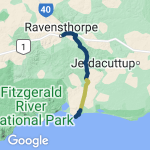
A rugged and partially complete rail trail on the south coast of WA. Located on the alignment of a historic government railway built to haul mining and agricultural products to the small port of Hopetoun.
Nearby Attractions
- The small agricultural and mining community of Ravensthorpe includes many historical buildings
- The small coastal community of Hopetoun, formerly known as Mary Ann Haven
- Scenic and rugged bushland
- Old mine workings around the former sidings of Kundip and Desmond
- The nearby Fitzgerald River National Park, an internationally registered biosphere reserve
Last updated: 20 December 2022
Four sections of the rail trail are currently open. The three northern sections form a contiguous trail between Ravensthorpe and Lee Creek (just south of Lee Rd). The southern section links Dunns Swamp Rd with the jetty precinct in Hopetoun. A 16 km section is missing between Lee Creek and Dunns Swamp Rd.
In the northern sections the trail surface consists mainly of coarse gravel, whereas the section near Hopetoun can be very sandy in places. Many bridges and culverts have been washed out over the years, making this trail unsuitable for bikes and horses. Due to its isolation and ruggedness, the trail is recommended only for experienced hikers.
Section Guides
Ravensthorpe to Desmond (15 km)
The northern trailhead is at the site of the former Ravensthorpe railway station (near the roundabout just east of town). There is a picnic table and maps of the railway walk incorporating the history of the district,
Heading east, the trails runs parallel to the South Coast Hwy for about 7 km before turning south. The next section runs along the foothills of the Ravensthorpe Range as the former railway alignment has been resumed by a nearby farm. The trail rejoins the former railway alignment about 2 km south of the highway.
Running parallel to the Ravensthorpe Range, the trail continues south for a further 4.5 km before meeting Elverdton Rd where it detours around the former Desmond Siding area, covered by tailings of a closed copper mine. The mine area is private property and extremely dangerous: STRICTLY NO ADMITTANCE. There are several connecting trails around Desmond including a pathway to the Mt Desmond lookout
Desmond to Kundip (10 km)
Desmond is 11 km southeast of Ravensthorpe and 38 km north of Hopetoun. The Desmond to Kundip section of the rail trail is about 10 km long and takes three to four hours.
On the eastern side of the Hopetoun–Ravensthorpe road, this section runs close and parallel to the usually dry Steere River. There are several small creek crossings that can become wet during and after heavy rain.
Kundip to Lee Creek (11 km)
Kundip is an abandoned townsite 19 km south of Ravensthorpe and 30 km north of Hopetoun. This section on the western side of the Hopetoun–Ravensthorpe road runs through bushland with wildflowers and places of historic interest. In July/August the intense blue Hovea elliptica flowers are very eye-catching, while between June and October the creamy climbing native Clematis pubescens drapes from the trees.
Towards the end of the trail, turn left at the marker for Lee Creek Rest Area. A short walk along a 300 m path of brings you to a picnic table, benches and an information bay. You can continue another 300 m along the railway until it crosses the sealed road.
Between Lee Creek and Dunns Swamp Rd the railway ran east of the main road through what is now cleared and cultivated farmland.
Dunns Swamp Rd to Hopetoun (5 km)
This section begins at Dunns Swamp Rd about 1.5 km east of the Hopetoun–Ravensthorpe road. Heading south for around 3 km, the trail surface is very sandy and not suitable for bikes.
After reaching The Esplanade, the trail heads west along a limestone track parallel to the Hopetoun foreshore. There are several points of interest on this section, including the old turntable and marshalling yards. The trail terminates at the site where the Hopetoun jetty joined the mainland just west of the present groyne, where a replica railway station has been built.
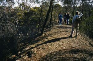
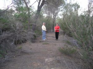
Walkers on the trail in 2002 Ann Williams
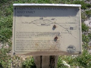
Information sign at the Hopetoun Rail Yard
The Hopetoun Rail Yard
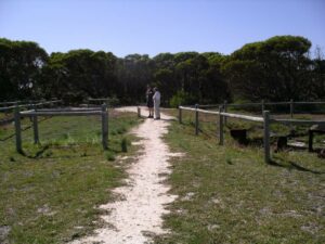
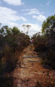
On the trail near Kundip
Sleepers are still in place at some locations Ann Williams
Do you know of a bike hire or transportation service on this rail trail that should appear here? If so, let us know at admin@railtrails.org.au.
Information and Links
See Services tab above for links to services and businesses along this trail
- The Shire of Ravensthorpe can email through PDF maps upon request
- Updates surrounding the trail’s condition are occasionally posted to this Facebook page: https://www.facebook.com/pages/Hopetoun-Ravensthorpe-Railway-Heritage-Walk-Trail/1589734981317531
To report any issues or problems please contact Shire of Ravensthorpe.
- Ravensthorpe Office: 9839 0000
- Hopetoun Office: 6820 8901
Contact Rail Trails Australia
To contact us about this rail trail, email wa@railtrails.org.au
Background Information
Traditional owners
Rail Trails Australia acknowledge the Wudjari people, the traditional custodians of the land and waterways on which this rail trail is built.
Development and future of the rail trail
This project was carried out by a sub-committee of Ravensthorpe Hopetoun Area Promotions in the early 2000s, with assistance from the Shire of Ravensthorpe and financial assistance from the WA Department of Local Government’s Community Facilities Grants Program and WA Tourism Commission’s Development Fund.
When complete, the Hopetoun–Ravensthorpe Railway Heritage Walk will form a 57 km continuous trail between Ravensthorpe and Hopetoun. Timeframes for the completion of the missing section between Lee Creek and Dunns Swamp Road remain uncertain.
Rail line history
The narrow gauge railway was built to connect mines in the Ravensthorpe area to the Hopetoun port and operated from 1909 to 1935. It was 54.7 km long, constructed of 45 lb per yard rail with jarrah sleepers and earth ballast. The route included stations at Hopetoun and Ravensthorpe, sidings at Three Mile, Seven Mile, Kuliba, Kundip, Desmond and 30 Mile, and a private spur and siding to Mt Cattlin Gold Mine.
The first locomotive, a Beyer Peacock 2-6-0, arrived by sea in 1908 from Kirup and was used by contractors. Up to five locomotives were used on the line: the last, G233, was removed in 1944 to Midland Railway Workshops where it was restored. Now known as the Leschenault Lady, it is housed at the South West Rail and Heritage centre in Boyanup.
One review of “Hopetoun – Ravensthorpe Railway Heritage Walk”
A fabulous trail that takes a step back in time of coastal town settlements and diverse landscape. Well worth taking this trail during spring and the Ravensthorpe Wildflower Show and Herbarium. Early September, with Mallie Fowl nests to discover.
I have maintained the trail with my husband and mother from Hopetoun to the Dunns Cottage area. Signage needs renewing, though mostly well-defined rail trail formations.