

- Potential Trail – This trail is not open or developed.
- The trail would be 45 km long making it an ideal one-day ride for the enthusiast or a multi-day tour. Good accommodation is available in both Port Lincoln and Coffin Bay.
- The trail would provide excellent views as it moves along the foreshore, through the Uley Basin, a bushland water catchment area, and past the rolling Almonta sand dunes near Coffin Bay.
- The trail would connect with and, in places, overlap with the 89 km Investigator Walking Trail which would also provide access to the Lincoln National Park.
- The trail would connect the two key tourism towns of Lower Eyre Peninsula, Port Lincoln and Coffin Bay.
- The trail would also connect with the Parnkalla Trail at Port Lincoln to extend the trail(walking) a further 25km beyond Port Lincoln to North Shields.
Nearby Attractions
- Fresh seafood, straight off the boat in Port Lincoln or fresh oysters in Coffin Bay.
- The seafood is complemented by fine wines from local vineyards.
- Stunning coastal bushland at Lincoln National Park and Coffin Bay National Park.
- Get wet by swimming with the sharks or sea lions, or farm oysters in waist deep water, or surfing the Southern Ocean rollers at Fishery Bay or Almonta Beach.
Last updated: 28 April 2024
The Port Lincoln to Coffin Bay Rail Trail would travel through varying scenery, from coastal bushland to inland water catchment areas and then finally along the edge of large rolling sand dunes.
Section Guides
Port Lincoln to just north of Tulka (4 km)
The trail would commence near the southern boundary of Port Lincoln city and follow the Investigator Trail along the old tramway alignment along the Proper Bay coastline for 4 km.
North of Tulka to the edge of the Almonta sand dunes (32 km)
This section of the trail would follow the tram line as it crosses Lincoln Conservation Park and then Uley Basin, a natural freshwater catchment and storage area which currently provides the majority of water used across Eyre Peninsula. The basin is currently depleted and alternative water supply, in the form of desalinated water, is being investigated. In the interim SA Water is closely monitoring the performance of Uley Basin and access to the tram line within the basin is prohibited. The future of the rail trail depends on the establishment of an alternative water supply and the recovery of the natural Uley Basin water level and quality.
Almonta sand dunes to Coffin Bay (9 km)
The tram line ends at the edge of the Almonta sand dunes, where the lime sand was mined and loaded. The trail would then pass along tracks and gravel roads on private land before linking with public roads within Coffin Bay.
Linkages with Side Trails
Parnkalla Trail (26 km total)
This is predominantly a walking trail around the Boston Bay shoreline, from the Axel Stenross Museum to Billy Lights Point, a distance of 11 km. It does extend a further 15 km out to the southern edge of Port Lincoln, although this section is not well-marked and very rough in places.
Investigator Trail (107 km)
This trail continues on from the Parnkalla Trail near the southern boundary of Port Lincoln City, and passes through the Tulka settlement and on into the Lincoln National Park, where it forms an extensive network of walking trails, many sections of which are suitable for mountain or gravel bike cycling.
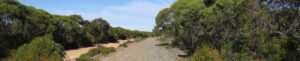
trail ballast adjacent to the service road near Tulka March 2024
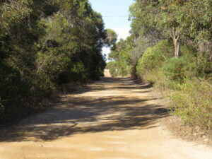
service road forms part of the Investigator Trail, south of Tulka March 24
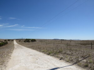
private road which will for part of the trail between the tramway terminus and Coffin Bay March 23
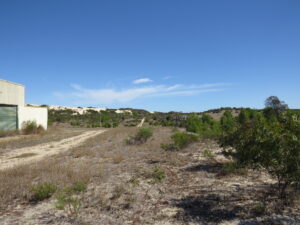
BHP tramway terminus sheds with encroaching sand hills in the background March 23
Do you know of a bike hire or transportation service on this rail trail that should appear here? If so, let us know at admin@railtrails.org.au.
Information and Links
The trail is a proposed Rail Trail only at this stage. It is not yet constructed or open. The tramway corridor passes through land occupied by SA Water and access is currently prohibited.
Contact Rail Trails Australia
To contact us about this rail trail, email sa@railtrails.org.au
Background Information
We acknowledge the Nauo and Barngala peoples, the traditional custodians of the land and waterways on which the rail trail would be constructed.
Rail Line History
The Coffin Bay tramway was a railway line located on the southern tip of Eyre Peninsula, covering a distance of 40 km from Coffin Bay to Port Lincoln. It was built and operated by BHP to carry lime sand from extensive sand dunes south of Coffin Bay to wharf facilities at Billy Lights Point on the outskirts of Port Lincoln, from whence it was shipped for steelmaking at Whyalla, Port Kembla, and Kwinana.
The line was operational from 1966 until 1989. The track was lifted in the early 2000’s and reused on the Eyre Peninsula railway line. But the coarse stone ballast remains in place over most of the length of the tramway.