


- Scenic ride or walk along the old rail reserve between Renmark and Paringa, avoiding the busy Sturt Highway
- Easy grades, ideal for children and novice riders
- Access points for many MTB trails, water sports and other highlights
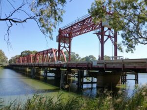
- Watch the lifting span of the historic Paringa Bridge in operation to allow large vessels to pass
- Side trips to Lock 5 or Murtho or follow the scenic Renmark riverfront path
Nearby Attractions
- Wine and fruit-growing area
- River towns
- Historic Paringa Bridge
- MTB trail access
- Water sports
- Irrigation history
- Historic paddle steamer
Last updated: 22 November 2022
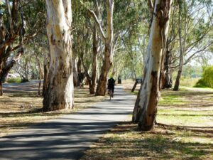
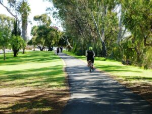
The Renmark-Paringa Rail Trail features a smooth hot-mix surface of adequate width. It is a popular trail, particularly at holiday times, as it provides safe access to two main caravan parks and both towns.
The Paringa Bridge lifting span operates daily at 9:30 am and 2:30 pm and is best viewed from Bert Dix Memorial Park. Make sure you are positioned on the side you want to be before the span lifts; it can be a long wait.
- Coffee shops, bakeries and restaurants in Renmark and Paringa
- Toilets and picnic facilities at Bert Dix Memorial Park
Section Guides
Nineteenth St to Patey Drive (2.0 km)
The trail starts off Nineteenth St opposite the Renmark Plaza shopping centre. Parking is available on-street or in the shopping centre car park. There is a BMX track, playground, picnic facilities and toilets close to the trail start.
The first section to Para St is paved; the remainder is hot mix. After crossing Para St the trail turns left and then parallels Eighteenth St/Sturt Highway. This area was once the railway station and freight yards; now it is a housing estate and Council offices. Just past the Council offices an old railway crane sits alone, the sole remnant of the station precinct.
Great care is required crossing the Sturt Highway as this is a major interstate freight route. The trail then passes behind houses on the edge of town with the highway to the right. At 1.8 km a ramp to the left allows access to the riverfront trail. Immediately following are the first two of four railway bridges over swampy waterways. Another ramp just after the second bridge accesses a trail that passes beneath the bridge, leading to Paringa Paddock and its many MTB and walking trails.
Patey Drive crosses the trail and is the highway access point for the Renmark Riverfront Caravan Park. Near the caravan park entrance are public toilets, BBQ and picnic facilities, river access and a boat ramp, and a boardwalk across shallow water to a small island for birdwatching. The caravan park café/kiosk is accessible from Patey Dr.
Patey Drive to Paringa (1.9 km)
A signposted gravel road 250 m beyond Patey Dr leads to the Paringa Paddock trails. Take care crossing the highway.
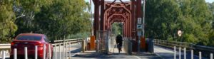
There are two more railway bridges to cross before the Paringa Bridge comes into view. Approaching the western end of the bridge, cross the entrance road to the Riverbend Caravan Park and the eastbound carriageway of the highway to reach the bridge’s central cycle path.
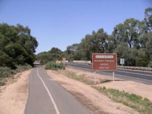
Paringa Bridge was built in 1927 as a multi-use bridge over the Murray, with vehicles sharing the central passage with the railway. Later, outrigger vehicle decks were added to either side, leaving just the railway in the centre corridor. This is now the cycle path, necessitating crossing the eastbound lane of the highway at both ends of the bridge. The lifting span is close to the Paringa end of the bridge
Leaving the bridge on the eastern side, cross the highway again to reach the remaining trail into Paringa. On the left you will see a museum and also some silo art. The trail finishes on a service road close to the Paringa store and post office. Paringa also has a bakery café, the Black Stump Gallery and a hotel.
Side Trails
Renmark Riverfront Trail (3.3 km)
The Renmark Riverfront Trail follows the western bank of the river from the Riverfront Caravan Park. It diverges through a housing estate briefly before returning to the river.
The Visitor Information Centre is opposite the Renmark Hotel. Bike hire is available through the Information Centre, best booked in advance by phone or online. The paddle steamer Industry is moored behind the Information Centre and has regular passenger steaming days.
Continuing north, the trail drops to river level as it passes in front of the Renmark Club before climbing back to street level before the old wharf area. The central shopping area is to the left and has bakeries, cafes and other shops.
The trail continues through shady parks to the main irrigation pumping station.
Paringa Paddock MTB Trails
Paringa Paddock is easily reached from the rail trail and has a number of walking and MTB trails. Maps can be obtained online or from the Visitor Information Centre in Renmark. Trails are a mix of single track and unsealed roads.
Lock 5 (1.7 km)
Lock 5 Rd can be reached from the eastern end of Paringa Bridge. Bert Dix Park has BBQs, toilets and picnic facilities. Continue on the lightly trafficked road past moored houseboats. Lock 5 and weir has well kept, shady grounds with a picnic area, BBQs and toilets. The historic barge Bunyip is displayed in the grounds and displays historical information and photographs about the barge and the locks.
Old Customs House (31 km)
Leave Paringa on Murtho Rd, uphill initially passing the scenic lookout on the left. Murtho Rd is sealed and lightly trafficked, though it does have a 100km/h speed limit. The terrain is mostly flat and passes irrigated orchards and open farmland.
Headings Cliffs Lookout 12.5 km from Paringa has great views. It is 1 km off to the left on a sealed road.
Turn left 15 km from Paringa on to Wilkinson Rd to visit Wilkadine-Woolshed Brewery overlooking a bend in the Murray River. It is less than 1 km from Murtho Rd.
Approximately 26.5 km from Paringa, just past the intersection with Millewa Road and cattle grid, the route of the old Chowilla Dam railway crosses Murtho Rd. Little evidence remains of the old line.
Old Customs House was established in the late 1800s to levy excise on goods shipped into SA by Murray River steamers. Today it is a base for houseboats and has a general store, and is the stepping-off point for the Border Cliffs Wetlands Walk.
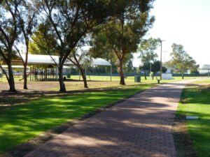
trail passes the Renmark Playground 2020
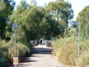
the trail leaving Renmark 2020
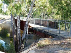
cycle path on the former Renmark rail bridge 2020
Visit to South Australia March 2010
Paringa bidge 2020
Paringa bridge. note the cycle path is located in the middle of the bridge 2020
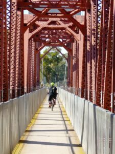
Cycle path on Paringa bridge.
Renmark riverfront reserve 2020
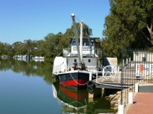
PS industry on the Renmark river bank 2020
Renmark river frontage trail 2020
Do you know of a bike hire or transportation service on this rail trail that should appear here? If so, let us know at admin@railtrails.org.au.
Information and Links
The rail trail is managed by Renmark Paringa Council. To report problems contact council@renmarkparinga.sa.gov.au or phone (08) 8580 3000.
For more information:
Contact Rail Trails Australia
To contact us about this rail trail, email sa@railtrails.org.au
Background Information
Traditional owners
We acknowledge the Meru people, the traditional custodians of the land and waterways on which the rail trail is built.
Development and future of the rail trail
The Renmark–Paringa Rail Trail was built following closure and removal of the railway.
There are no plans to extend the trail through to Berri or Barmera at this stage.
Rail line history
The Barmera line branched east at Tailem Bend from the main Adelaide to Melbourne line. It was opened to Paringa in 1913. World War I delayed construction of the Paringa Bridge and the railway to Renmark did not open until 1927. The line was extended to Barmera in 1928.
The line closed west of Paringa in 1984 and tracks were removed by 1986.
In the 1960s, a branch line was built which joined the main line southeast of Paringa, near the Wonuarra siding. Built to support construction of the proposed Chowilla Dam, it was 27.3 km long and went northeast to Murtho to the south bank of the Murray. . Construction of the dam was cancelled in 1967; the rail line was removed without ever being used (though there are reports that one test train did run on the line). The route of the line is still visible using Google Earth.
Top South Australian tourism towns announced
Posted: 10/06/22
The Tourism Industry Council South Australia named the Riverland town Renmark, a three-hour drive from ...
More...