
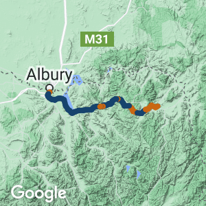
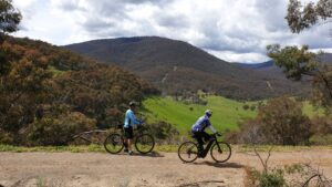
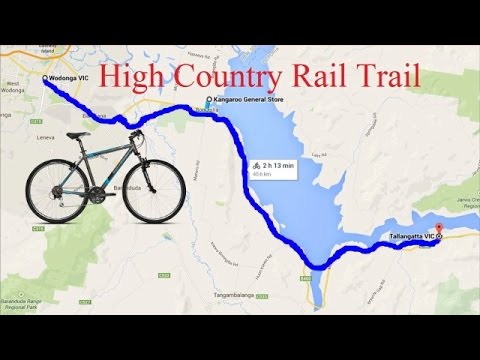
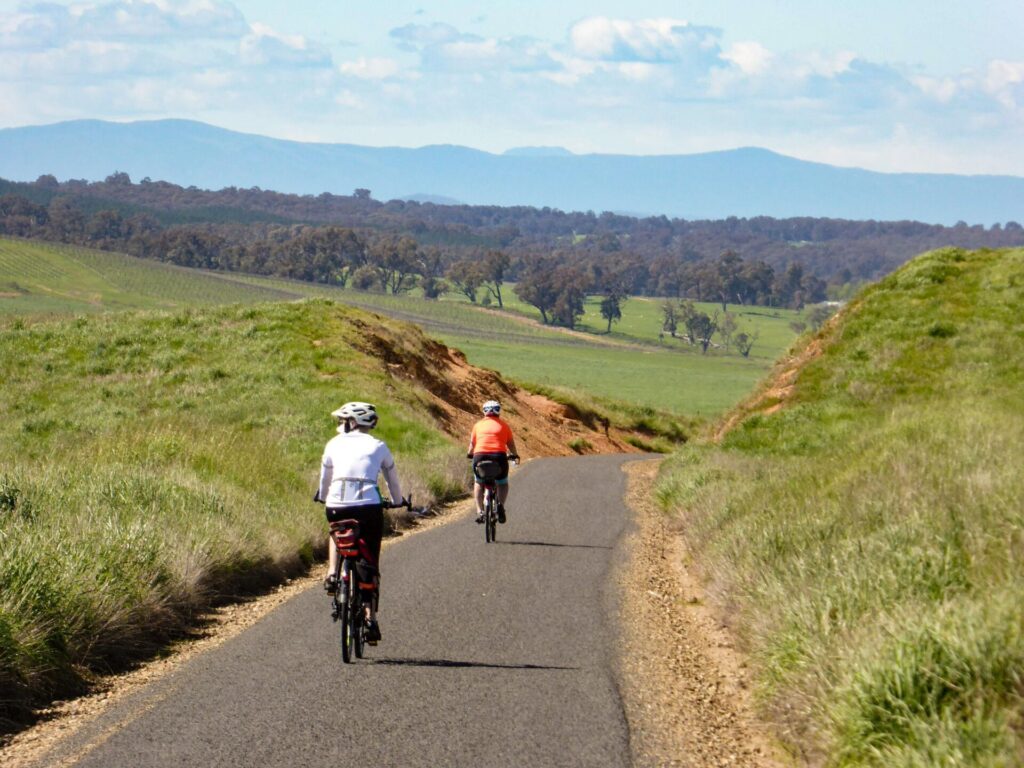
- Experience Lake Hume, one of Australia’s largest reservoirs, high timber bridges and the foothills of the High Country
- The trail traverses farmland near the shores of Lake Hume and forest at Shelley, once Victoria’s highest railway station
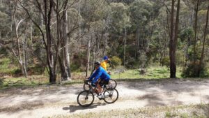
- The trail is undulating to Bullioh with some moderate gradients. Bullioh to Shelley is all uphill at the steepest gradient trains could manage. Plan your trip
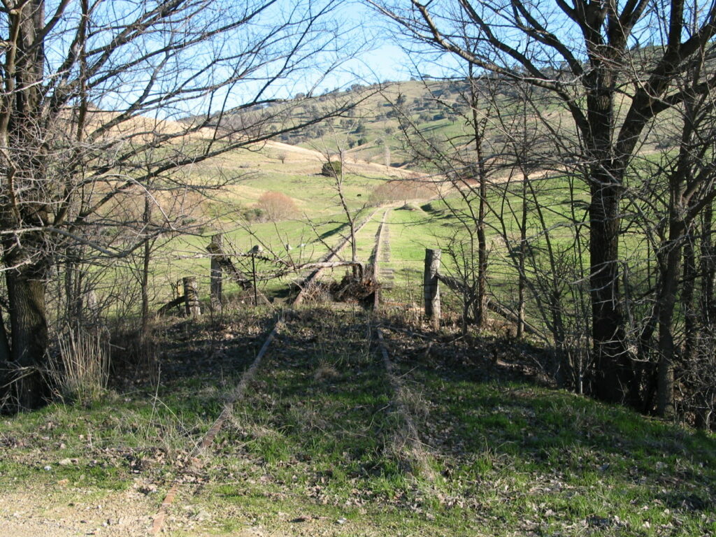
- Trail surface is of varying quality beyond Old Tallangatta
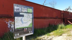
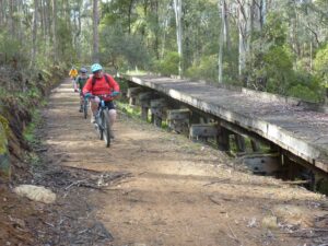
- The 600m Sandy Creek Bridge is a scenic landmark
Nearby Attractions
- Albury/Wodonga has many attractions including the Murray River at Wodonga and Bonegilla Migrant Museum
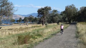
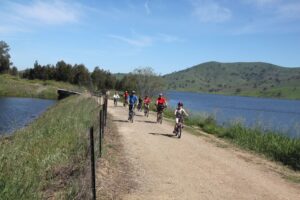
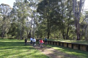
- Recreation facilities around Lake Hume
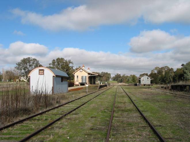
- Old Tallangatta, the town that moved!
- Many National and State Parks to explore. There are good views from lookouts and mountaintops (including the Main Range of Kosciuszko National Park) and plenty of picnic and camping areas
Last updated: 23 March 2024
The High Country Rail Trail will eventually be 112km long, in three distinct sections:
- The 6km high-standard urban Wodonga to Bandiana section
- The 37km good-standard rural section around Lake Hume to Tallangatta and Old Tallangatta
- The 38km section to Shelley is for the more adventurous, but well worth it
Albury/Wodonga is a major regional centre with all services while Tallangatta has some services. There are no services beyond Tallangatta.
Section Guides
Access Points
- Wodonga: many access points; parking on side roads
- Bandiana: car park at Whytes Rd
- All other station sites have carparks
- Old Tallangatta: no parking at trailhead itself – park at Mitta Bridge rest areas or in Old Tallangatta across causeway
- Shelley – Take Avondale Rd off Murray Valley Hwy at Shelley, past the Shelley accommodation camp
For public transport options click on “Get Around” below.
Albury/Wodonga to Bandiana (6 km)
- From Albury station follow the old Hume Hwy 5km toward Wodonga across the Murray River floodplain to High St and the former Wodonga railway station precinct, which is well worth a visit
- From the Wodonga station precinct travel 200m east along Reid St to the start of the rail trail
- From here to Bandiana is a very smooth asphalt surface
- Military and history interpretive signs toward the Bandiana Military Museum provide an insight into the role the region and Australia has played in conflict and peacekeeping
- Many other interpretive signs, so many excuses to stop and read. Kangaroos are common near the military facilities
Albury and Wodonga are major regional cities with all facilities. There is a hotel and takeaway near Bandiana.
Bandiana to Huon (Huon Reserve) (17 km)
- A bitumen surface to about 1.5km before Huon, then a wide, smooth gravel surface to Huon (Huon Reserve)
- The army has taken over some of the former line and the very long trestle bridges across the Kiewa river flats have been demolished, so a diversion with boardwalk and low level bridges has been built across the Kiewa River flats.
- There is a steep gradient on Whytes Rd
- Make use of the picnic tables at Kiewa River to enjoy the scenery
- After crossing Kiewa River, the trail joins the original rail alignment; leaving the river red gum forest the trail rises slowly to Mahers Rd, Bonegilla with the first views of Lake Hume
- This trail features sites rich in cultural history such as Bonegilla station site
- At Mahers Rd, an on-road diversion to the large dam wall is worthwhile. Follow Bonegilla Rd north; along the way visit Block 19, the Bonegilla Migrant Experience Heritage Park
- From Mahers Rd the trail passes beneath Murray Valley Hwy then heads south with the Mitta Arm of Lake Hume to one side, hills on the other and mountains in the distance. There are many locations for a refreshing dip on a hot day, especially when the water level is high
- The trail descends to Huon station where the platform, goods shed, weighbridge and some rolling stock remain. If water levels are very low, the remains of the original station site can be recognised further down the hill
Huon to Tallangatta (12 km)
- From Huon to the 600 m Sandy Creek bridge with its distinctive ‘red sticks’.
- From Sandy Creek to Tallangatta the trail surface has one side sealed and the other smooth gravel
Tallangatta is a small regional town with some food and accommodation, including a bakery and choices for coffee.
Tallangatta to Old Tallangatta (8 km)
- The trail is sealed all the way from Tallangatta to the Mitta bridge, an impressive structure
- At Old Tallangatta, turn left at the over-bridge and follow the road for 1 km to see the few remaining buildings of the township; if the weir level is low take a stroll around the building foundations
- There is an interpretive sign at a viewing point up on the highway
- No facilities at Old Tallangatta
Old Tallangatta to Shelley (38 km)
- This section is for the more adventurous, but has many rewards
- No drinking water or toilets after Tallangatta
- From Old Tallangatta to Bullioh the trail is basically flat and a little rough as it winds up the valley
- A stone step crossing of Tallangatta Creek requires a diversion on to Murray Valley Hwy in wet weather
- A short on-road diversion at Bullioh around the station area
- From Bullioh the trail climbs 460m up to Shelley at the maximum gradient trains could manage almost continuously for 28 km. Cyclists should consider starting at Shelley unless they are quite fit or on a fully charged e-bike
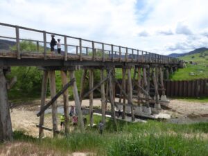
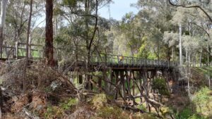
- There are many reasons to stop with wonderful views between Bullioh and Derbyshire and three tall timber bridges, including the highest in Victoria
- After Darbyshire the trail enters forest and follows a creek
- A diversion besides the highway is necessary to get around the 76m long Boggy Creek bridge near Koetong (viewing platform)
- Boggy Creek bridge can be reached by car; from Wodonga, turn left off Murray Valley Hwy before Koetong on the Mt Lawson road that leads to Mt Lawson State Park
- From Koetong, after a short descent to Koetong Creek, it is a steady but picturesque climb to Shelley
- Many large timber bridges in this section, some of which have been restored by voluntary community participation; others have a diversion around them
- Just before Shelley the rail trail becomes a road for about 1km with a rough surface and is used by log trucks.
- Enjoy a break in the forest at Shelley station, at 781 m Victoria’s highest station site
- The only facilities are at the Shelley Forest Camp (booking required)
- Other places to visit include the summit of Mt Lawson and its loop nature trail, Conic Range Walking Track, a 1.5 km walk off Firebrace Rd, great views of the Koetong Creek Valley, and Avondale Gardens Reserve. Follow the signs from Shelley off Avondale Rd
Beetoomba (9 km)
Part of the future section to Cudgewa and Corryong is accessible, but it is only for keen walkers and mountain bike riders as the surface is rough and there are low-level crossings around the four bridges in this section.
![The former Wodonga Railway Station is now Junction Square [2021]](https://www.railtrails.org.au/wp-content/uploads/2021/12/V42-032-Wodonga-station-2021-03-6405-4-300x202.jpg)
The former Wodonga Railway Station is now Junction Square [2021]
![The station is now Junction Square [2021]](https://www.railtrails.org.au/wp-content/uploads/2021/12/V42-032-Wodonga-station-2021-03-06_190612-300x168.jpg)
The station is now Junction Square [2021]
![Heading out of Wodonga where the broad and standard gauge lines joined up. [2019]](https://www.railtrails.org.au/wp-content/uploads/2021/12/V42-031-Wodonga-20191012_130153-300x169.jpg)
Heading out of Wodonga where the broad and standard gauge lines joined up. [2019]
![Heading out of Wodonga [2019]](https://www.railtrails.org.au/wp-content/uploads/2021/12/V42-031-Wodonga-2019-10-0550-300x169.jpg)
Heading out of Wodonga [2019]
![There are plenty of kangaroos to be seen around Bandiana, finding haven in the nearby military bases [2019]](https://www.railtrails.org.au/wp-content/uploads/2021/12/V42-0063-Bandiana-2019-03-P1050185-Kangaroo-300x169.jpg)
There are plenty of kangaroos to be seen around Bandiana, finding haven in the nearby military bases [2019]
![Enjoying the rail trail at Bandiana near Whytes Rd and the former sale yards [2019]](https://www.railtrails.org.au/wp-content/uploads/2021/12/V42-063-Bandiana-2019-04-0506-300x169.jpg)
Enjoying the rail trail at Bandiana near Whytes Rd and the former sale yards [2019]
There is a multitude of engaging signs providing background on local, railway and natural history. (2019)
![The deck across the Kiewa River flood plains [2015]](https://www.railtrails.org.au/wp-content/uploads/2021/12/V42-112-Kiewa-River-board-walk-2015-10-6714-300x169.jpg)
The deck across the Kiewa River flood plains [2015]
![Bonegilla station site was once the busiest on the line bringing in tens of thousands of migrants to a new life [2020]](https://www.railtrails.org.au/wp-content/uploads/2021/12/V42-137-Bonegilla-2020-300x169.jpg)
Bonegilla station site was once the busiest on the line bringing in tens of thousands of migrants to a new life [2020]
![The Bonegilla Migrant Museum celebrates a crucial part of our recent development [2010]](https://www.railtrails.org.au/wp-content/uploads/2021/12/V42-135-Bonegilla-Migrant-Museum-2010-10-0176-300x225.jpg)
The Bonegilla Migrant Museum celebrates a crucial part of our recent development [2010]
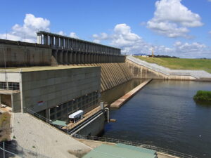
The impressive Hume Dam near Bonegilla (2011)
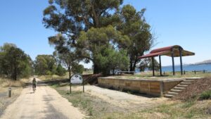
Community groups have restored the Ebden station platform (2013)
Summer on Lake Hume at Ludlows Reserver (2013)
![Crossing the reinstated 600m long Sandy Creek bridge is a highlight of the rail trail, especially with water under it [2024 Garry Long]](https://www.railtrails.org.au/wp-content/uploads/2024/03/V42-250-Sandy-Creek-bridge-2024-03-18_102914-300x163.jpg)
Crossing the reinstated 600m long Sandy Creek bridge is a highlight of the rail trail, especially with water under it [2024 Garry Long]
Lake Hume is full as riders approach Tallangatta. (2012)
![Riding between Tallangatta and Old Tallangatta [2019]](https://www.railtrails.org.au/wp-content/uploads/2021/12/V42-319-Old-Tallangatta-to-Tallangatta-2019-10-13_144305-300x169.jpg)
Riding between Tallangatta and Old Tallangatta [2019]
![Crossing the long Mitta Mitta river bridge near Old Tallangatta [2019]](https://www.railtrails.org.au/wp-content/uploads/2021/12/V42-369-Old-Tallangatta-2019-10-0583-300x169.jpg)
Crossing the long Mitta Mitta river bridge near Old Tallangatta [2019]
![Passing under the Old Tallangatta Rd [2019]](https://www.railtrails.org.au/wp-content/uploads/2021/12/V42-369-Old-Tallangatta-2019-10-0582-300x169.jpg)
Passing under the Old Tallangatta Rd [2019]
![Summer ride east of Bullioh into the mountains [2023]](https://www.railtrails.org.au/wp-content/uploads/2023/01/V42-412-Heading-east-from-Bullioh-2023-01-225x300.jpg)
Summer ride east of Bullioh into the mountains [2023]
Volunteer restored Dry Forest Creek bridge completed the trail from Wodonga to Shelley in Oct 2019

One of the famous 'high bridges' near Derbyshire. This one is the highest remaining in Victoria, with an easily graded bypass around it. (2019)
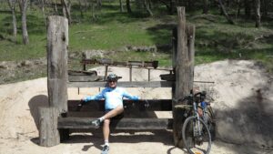
Several of the bridges have volunteer made creative and practical sculptures all from reclaimed materials. (2019)
![There is 28km of climbing from Bullioh up to Shelley, easy going down! [2019]](https://www.railtrails.org.au/wp-content/uploads/2021/12/V42-410-Derbyshire-to-Bullioh-2019-10-0559-300x169.jpg)
There is 28km of climbing from Bullioh up to Shelley, easy going down! [2019]
Allow time to take in the spectacular views between Bullioh and Koetong (2019)
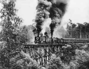
Two K class locomotives battle up the never ending curves and grades as they cross Boggy Creek bridge with an excursion train in the 1960s
Cycling besides the Dry Forest Creek near Koetong (2019)
![The rail trail occasionally pops out into farmland around Koetong. [2022]](https://www.railtrails.org.au/wp-content/uploads/2022/04/V42-458-Darbyshire-to-Boggy-Creek-2022-04-18_112203-300x169.jpg)
The rail trail occasionally pops out into farmland around Koetong. [2022]
The Koetong Creek bridge is one of five restored by volunteers (2019)
Cruising down from Shelley to Koetong. Where bridges are bypassed they are evenly graded. (2019)
![Another of the bypassed bridges between Koetong and Shelley [2022]](https://www.railtrails.org.au/wp-content/uploads/2022/04/V42-514-Koetong-Creek-bridge-2-sign-2022-04-18_102959-300x169.jpg)
Another of the bypassed bridges between Koetong and Shelley [2022]
Shelley station was the highest in Victoria. It is is now very quite, ideal for a picnic. (2012)
![A lot of the features of the High Country Rail Trail have been built by volunteers. Rotary volunteers work on handrails for the next section across the Murray River flood plains at Wodonga [2021]](https://www.railtrails.org.au/wp-content/uploads/2021/12/V42-032-Murray-River-bridges-handrails-Rotary-2021-12-FRIENDS-300x169.jpg)
A lot of the features of the High Country Rail Trail have been built by volunteers. Rotary volunteers work on handrails for the next section across the Murray River flood plains at Wodonga [2021]
Summer on the rail trail
Spring on the rail trail


Public Transport
There are numerous trains and buses to Albury and Wodonga from Melbourne and Sydney. As always bicycle carrying restrictions apply.
There is only one return bus service a week from Wodonga to Tallangatta on Friday. None to Shelley.
Refer to the PTV web page for map and timetables, or your navigation program of choice.
High Country Rail Trail Bike Transport
Contact Rob Caddell on 0417 294 234 or Phil Coulson on 0427 785 467 from the High Country Rail Trail Tallangatta Advisory Group for availability and full details.
Rates are on a per-car basis and funds raised go towards the rail trail.
Unfortunately there are no bicyle rental services for this rail trail.
Do you know of a bike hire or transportation service on this rail trail that should appear here? If so, let us know at admin@railtrails.org.au.
Information and Links
The trail is managed by the community organisation Parklands Albury/Wodonga with assistance from voluntary advisory groups along the rail trail.
For any management issues contact Parklands Albury/Wodonga railtrail@parklands-alburywodonga.org.au or at the High Country Rail Trail Official Site www.highcountryrailtrail.org.au
Contact Rail Trails Australia
To contact us about this rail trail, email vic@railtrails.org.au
Background Information
Traditional Owners
We acknowledge the Waveroo and Jaitmatang people, the traditional custodians of the land and waterways on which the rail trail is built.
Development and future of the rail trail
Many developments are under way and planned to improve this trail.
Parklands Albury/Wodonga, in conjunction with three local voluntary advisory groups, is working on improving the Old Tallangatta to Shelley section and opening the Shelley to Cudgewa section.
When the rail bypass of Wodonga opened, Rail Trails Australia supported local organisations to extend the trail from Bandiana into Wodonga; this is now complete to a high standard, providing an important backbone for the local off-road path system and preserving an important piece of history. Rail Trails Australia supports extending the rail trail across the Murray floodplains toward Albury.
Development of the trail began in 1996. Highlights of its development include
- opening of the 600 m Sandy Creek bridge in 2012 to link Bandiana and Tallangatta
- opening in 2019 of the fifth volunteer-restored bridge at Dry Forest Creek at Bullioh to link Tallangatta with Shelley
Railway History
Construction of the branch line began in 1887 and reached Tallangatta (now Old Tallangatta) in 1891. Cudgewa was not reached until 1921 due to the difficult terrain and labour shortages. According to legend, Corryong and Tintaldra were arguing over which should get the railway but the era of the motor car arrived before the argument could be settled, leaving the small township of Cudgewa as the terminus.
Construction of Hume Dam required the line between Ludlows and the present Tallangatta to be shifted up the hill in the early 1930s. In the 1950s the level of the dam was raised requiring further track deviations, the lifting of the Sandy Creek bridge and the shifting of the entire town of Tallangatta.
During the 1960s the railway carried construction materials for the Snowy Mountains Scheme as well as regular cattle and general goods trains. Construction also sped road improvements in the area, increasing competition for the railway. The last regular goods train ran in 1978 and the line officially closed in 1981.
Observing the remains of Bonegilla station platform, with only a few farmhouses in sight, it is hard to believe the part this area played in the lives of so many Australians. During World War II a major military training camp was established at Bonegilla, and following the war until 1971 the location was a reception centre for more than 320,000 migrants; you can listen to their stories in the excellent visitor centre at Block 19 (off Bonegilla Rd on the way to the dam wall). Remarkably, despite this number of people arriving in Bonegilla a station building was never built, let alone a siding. Now the former station’s small claim to fame is its native grassland reserve.
Also at Bandiana South is a large military museum that provides a vivid reminder of what was until recent times a very large military presence in the area.
Wodonga’s and Bandiana’s large railway facilities are now largely gone.
Lake Hume Cycle Classic – a community event
Posted: 15/02/24
John O'Brien (Rail Trails Australia Regional Representative for NSW) and his partner Kathy recently participated ...
More...New bridge for High Country Rail Trail
Posted: 04/01/24
Exciting news that the design and funding has been approved for a new bridge over ...
More...Back by popular demand is this High Tea gourmet ride
Posted: 08/05/22
The High Tea gourmet ride is back by popular demand. Bike riders leave Huon Reserve, ...
More...High Country Rail Trail Improvements
Posted: 23/04/22
The picturesque 80km High Country Rail Trail in north east Victoria is undergoing significant improvement: ...
More...Australia’s Longest Rail Trail Bridge Open
Posted: 20/11/12
Hundreds enjoyed a beautiful spring day for the long awaited opening by local state member ...
More...Sandy Creek Bridge Contruction to Start (VIC)
Posted: 27/09/11
Artists impression of the new Sandy Creek Bridge. Credit: ...
More...Nearby Trails

Murray to Mountains Rail Trail
250 km northeast of Melbourne
116 km


Culcairn – Corowa Rail Trail
520 km southwest of Sydney
2 km
Tumbarumba to Rosewood (Riverina Highlands) Rail Trail
470km south of Sydney, 460km north of Melbourne
21 km

Batlow – Tumut Rail Trail
400 km southwest of Sydney

Wagga Wagga to Ladysmith (Riverina Highlands) Rail Trail
460 km south-west of Sydney
Nearby Trails
Murray to Mountains Rail Trail
250 km northeast of Melbourne
116 km
Culcairn – Corowa Rail Trail
520 km southwest of Sydney
2 km
Tumbarumba to Rosewood (Riverina Highlands) Rail Trail
470km south of Sydney, 460km north of Melbourne
21 km
Batlow – Tumut Rail Trail
400 km southwest of Sydney
Wagga Wagga to Ladysmith (Riverina Highlands) Rail Trail
460 km south-west of Sydney
41 reviews of “High Country Rail Trail”
We rode from Ebden to Tallangatt and back. It was mainly sealed but there were parts that were on fine gravel. Very scenic and comfortable ride next to the lake – many cattle came to view as we were riding.
My neighbour was the Cudgewa station master so couple of years ago I did this trail. I caught the V/Line train from Melbourne to Wodonga and rode with tent and panniers. First night I camped 55km on the trail up the hill above Bullioh it was lovely bush and peaceful. Second day at Shelley station tried to navigate the derelict rail reserve amongst the pine plantation without a proper map and got lost camped out. Day three got onto main road to Cudgewa but with no where to camp continued on to Colac Colac campground. Lovely swim, rest and meal in Corryong before returning the same way back (minus getting lost) Tallangata pub had a $40 room and a cast iron bath (heaven) Day five easy ride back to Wodonga and train home. A wonderful trip and I will return.
We rode the trail over 2 days on e-bikes, my wife Lynda and our friends Darren and Fiona, stayed at Quest in Wodonga (we were allowed to keep our bikes in our room/balcony), which is located right near the beginning of the trail.
Day 1, Wodonga to Tallangatta and back, about 31 degrees, it was a great day with plenty of amenities along the way, had lunch at Tallangatta Bakery, where we learned the correct pronunciation of the town, plenty of photos and drone footage. We encountered 2 brown snakes, so keep an eye out. Plenty of frequent rest stops helped to deal with the heat. But overall a really great experience.
Day 2, Tallangatta to Shelley and back, weather forecast was for increasing rain in the afternoon (they got the forecast correct), drove to Tallangatta and started riding at 9am looking to conserve batteries wherever possible. There are no amenities for this portion of the trail. The timber bridges are quite amazing, and the scenery is spectacular, really enjoyed the pine forest section. The steady climb is long and not for the faint hearted and very rewarding to get to Shelley Station, it was 1:30 when we turned around and headed for our lunch at Koetong Hotel, we missed the kitchen, closed about 2pm, we were 15mins late and couldn’t call ahead due to no phone service. Headed back to the trail via Edgar Rd, Murray Valley Hwy didn’t seem appealing. Really enjoyed the well deserved roll back down. The rain was right on time and we were drenched for the last hour. We were cold, tired, hungry and sore. This is a tough trail but very rewarding.
We would start and finish from Old Tallangatta if we were to do it again, to help with battery and time.
Don’t be discouraged by the hard parts, just be prepared, plenty of food, drinks, Aerogard and Stingose Happy Trails.
Day1, 5 stars
Day2, 3 stars – lack of amenities, peeing in the bush is not great for the gals.
After a few days in Canberra where we rode around lake burley griffin we relocated to Tallangatta for the fourth rail trail for this trip. We rode this trail over 2 days. The first day was Tallangatta to Wodonga. It was a bit chilly, then beautiful sunny weather. The Sandy Creek Bridge is a highlight. Beautiful riding by the lake then the run into Wodonga where the station precinct is really well done. Then back to the caravan park at Tallangatta right on the lake. Very quiet with brand new amenities and a friendly manager. 75km return.
The next day saw us head off towards the Darbyshire trestle bridges. We stopped at the old tallangatta lookout then over a bit rougher track and a couple of detours. Climb up to the bridges is great, steady but not steep. We stopped after the second bridge at a recalcitrant gate. Lovely descent from there then flattish back to Tallangatta for a 50km ride. We will come back again to complete the trail to Shelley.
My husband and I rode just a small section today from Wodonga CBD (Reid Street) to Kiewa River crossing. It was wonderful to see so many people utilising the trail today including a local school fundraiser walkathon. Can confirm that it is a steep descent at Whytes Road which then leads down to the Kiewa Flats. Great care needs to be taken on this section due to flood damage, the track is very rough in spots with uneven gravel and rocks – not suitable for road bikes in this section. There are signs at the river crossing to advise riders to dismount when needed due to the damage. We will come back to complete the rest of the ride to Tallangatta at another time, what we did ride in the first section was most enjoyable.
My husband and I rode this trail on our e-bikes. We also camped along the trail in our self-contained slide-on camper. We began at Shelly and rode as far as we felt like riding each day and turned around and went back up to the camper for the night. We then moved the camper down to the point where we turned around and camped there for the night and rode the next section. There are plenty of places to access the trail from the road and places to camp. We did not see another soul on the trail and it was a beautiful ride. We did this ride in late August/early September. One section had some protective magpies. 😁 We had the best time on this trail, dogs were allowed and we had our two miniature schnauzers in baskets on the bikes. Fabulous ride.
We created a loop of the region incorporating the HCRT. We got the train to Wodongoa, Took the trail existing the town, and the diverted north at Pollards road toward the Hume Damn. Crossed the damn wall, which is spectacular, and no cars, then stopped at the lovely cafe at the Lake Hume village. We then followed the Riverina Hwy (which is not too busy, and has a shoulder) back to Vic, crossing the stunning Bethango Bridge. We then road along the Murray River scenic road, which is epic. There are a lot of ascents and descents, but it not like you're riding up a mountain, an ascent never lasts more than a km or so. On night 1, we detoured off the Murray River rd, heading south past Granya and camped at Cotton Tree Campground. A beautiful and quite camp ground.We did a lovely walk along the river in the morning. Bring your own supplies though, as there are no shops etc. On day 2, we headed back to the Murray River rd, and continued east. There are quite a few nice looks to stop at, with tables and chairs, but no water, so you want to carry plenty, but if you get desperate, the river is never too far away. Later in the day we headed south again along Guy Forest rd. The first half is sealed and relatively flat. But then it becomes rough and ascending. I would only recommend this if you are fit and with a sturdy bike. In retrospect, I would ride along the Murray River Rd all the way to Walwa, and stay at the caravan park there, and I believe their is a pub too. Even though it is significantly more disance, it is all sealed and as I said, the scenery is epic. There was not much traffic when we did it either, which was during the ANZAC long weekend. Guy;s Forest rd intersects with Shelly's Rd, we camped by a creek not far off Shelley's Rd, following an access trail. Day 3: we continued along Shelley Rd, which is sealed, the ascent goes for kms, so only do it if you're fit. We were carrying lots of wait and had ordinary bikes, so if you consider yourself fit, it's doable. We go to Shelly, and joined the Railtrail. It was rougher than expeted , but at least it's downhill. We stopped at the Koetong pub for lunch, following signs on the trail indicating where to exit. Then we camped at Tallangatta. We stayed at the showgrounds. It was 5 bucks, and there are hot showers and toilets. Day 4: cruised back into Wodonga and got the late morning (or was it early arvo) train back to Melbourne.
I highly recommend doing a loop like this, it was challenging at times, but we loved the adventure.
Rode Wodonga to Tallangatta and back and stayed in caravan park. Top scenery. will be returning to ride new section.
Seven riders and I enjoyed this trail last week. First day we rode from Tallangatta to the outskirts of Wodonga and back. Fairly flat, sealed most of the way and very scenic. Lots of picnic areas along thw way. Next day we rode from Bullioh to Tallangatta, where the wonderful fellas from the rail trail commmittee gave us and our bikes to Shelley to start a 500m descent. The surface is a little rough, particularly for the first 1km, but what spectacular views! My new favourite rail trail for scenery.
We rode Old Tallangatta to Shelley, 77k return. Some repaired surfaces were a bit soft and there is obvious water damage to parts of the trail. Steady climb up tested our ebikes, but we were able to return with a few k's still in the batteries. Lovely views, good to see old bridges still in place, even if unridable. Good signage along the trail. It was disappointing to have to open and shut at least 14 gates. Ramps have been put in at many spots, but it would be nice to have them installed at all gates.
We rode from Old Tallangatta up to Shelley and return today, a total of 77kms. This is the more adventurios section of the HCRT.
We have ebikes with long range batteries, but the long uphill really drains the battery much more than normal riding. Thankfully the long downhill on the way back ensured we made it back with a small amount of charge remaining at the finish. Some of the newer surface treatments are a bit soft after recent rain, causing extra drag. This is a great part of the trail, with fantastic views, and beautiful old timber trestle bridges. However the many closed gates, (we counted 14), are a real spoiler for this part of the trail. Some of the gates have a small ramp next to the gate, aleviating the need to dismount, undo the gate, wheel the bike, and secure the gate, before mounting up again and continuing. Tends to be very tiring after doing it 28 times.
The trail can be quite rough in places, and we had to stop on numerous occasions to remove the many branches and sticks that had fallen across the track.
We only saw one other rider on the trail today, despite being school holidays and lovely weather.
We camped at the Tallangatta Showgrounds and on day 1 rode from Tallangatta to Shelley and return.
The gradient was much more gentle than the map suggested and we had no issues going up the steady ascent. Wait to have a break on the shady bench.
Before you leave, check the Koetong Hotel. It is not open every day, but the kitchen is not open on Wednesdays, although they were able to give us a toasted cheese and ham sandwich.
The last section to Shelley is the prettiest with plenty of shade.
The roll back down to Tallangatta was great and much quicker.
Day 2 we did Tallangatta to Wodonga and back. Lots of options regarding lunch in Wodonga.
Very informative and creative things on the trail. Very enjoyable riding for us.
Having a great time poking around exploring bits and pieces of this great trail.
Rode Wodonga to Koetong return today. Middle creek was 50 mm over the causeway on Whytes Road but then ran into water at Kiewa River. Backtracked and must have jagged a quiet time on Murray Valley Hwy as it didn't feel too exposed. Coming back this arvo the Hwy does have a shoulder but it pinches out at the bridges and the road was busier.
Magpies are doing the swoop
This rates 5 stars, fat fingered!
Today rode Tallangatta to Wodonga on hybrid bikes with panniers. Good surfaces, great views over the water, lots of birds life. Especially enjoyed Sandy Creek Bridge and the board walk and low level bridges at Kiewa River Flats.
We rode this trail in 2 separate rides. 1st day was Tallangatta to Wodonga. It was a bit chilly, then rain on way back. There's a very steep but short climb at the end of main trail before Bandiana. The barrier at the top is too close to the crest of the hill, so be careful as you approach. Flat ride into Wodonga. The Sandy Creek Bridge is lovely. New surfaces laid near Ebden and Ludlows reserves. Scenery quite nice, only spoily by traffic noise in places. Tallangatta a quaint old town with history worth reading.Stayed at local Van patk run by Goulbourn council, clean, tidy, new facility block.
2nd ride was to towards the Daryshire trestle bridges #1 and #2. Watch the deviation red arrow signs before Bullioh, and near the Bullioh station site. We wasted 30 mins after taking a wrong turn. Climb up to the bridges is great, especially on the e bikes, but lots of gates to open and close. Leave them as you find them.We will return one day to complete the trail to Shelley. We loved the big wooden seat at Darbyshire trestle bridge #2 where we lunched. Ride back was uneventful, but stop at the old Tallangatta lookout for some history lessons.
Rode down from Shelley last Monday, wonderful scenery and a lot of water in the creeks and even the waterfall. Also bonus walnuts at aptly named Tuckerbox Creek bridge.
Lots of improvements, refer to the News item today on the website.
The website description and map has been updated to reflect the improvements.
14 April 2022
We did the High Country Rail Trail from Shelley down to Tallangatta. We were lucky to find someone to drive with us and our bikes to Shelley station and drop us off and drive our car back to Tallangatta.
Wow what a beautiful, stunning and historic ride back down. I took loads of pics and we took our time and read all the interp signage along the way.
We rode into the Koetong Pub for a morning coffee and chat to Julie. Highly recommend doing this, its 2.5ks into the pub and then ride back into the trail.
We took a pack lunch with us, which we enjoyed at one of the trestle bridge sites.
If you can organise a 'shuttle', I highly recommend doing this track from Shelley downhill.
We were on E MTBs, I recommend MTB as it is a little rough in some places
Just do it! Its a lovely scenic ride.
Hi Kerry. We’re off to do the High Country trail in a couple weeks and had the same idea to get a lift up to Shelley and ride back down to Tallangatta. Who did the transport for you? Thanks for your help. Rebecca
Did this trail Nov 2021. I rate it #2 – just behind Lilydale-Warburton and just ahead of Melbourne Eastern – city – beach loop. (Based on the mighty "this is what I reckon" ratings system).
The climb is fairly challenging. But if you make it you'll have no probs getting back down 🙂
Be aware that this is, I think, the steepest rail track in Aus. So, it's not exactly lowest gear but it's just a tad steeper than some other rail trail slopes.
But a great ride!
We stayed at Tallangatta and did East-West separately.
Awesome track and thanks to all involved in making it happen!
..peterw
Loris Cassar
22/11/2021
Myself and a group of cyclists, Base camped at Tallangatta. 1st day we intended to cycle to Wodonga, we only got as far as Bonegilla Living Experience then to the Dam wall. That filled in the day.2nd day we started at Tallangatta and cycled to Shelley, a very steady 30km hill climb up to Shelley, camping overnight at Shelley then a lovely downhill experience the next day in the rain. We experienced a variety of scenery and track surfaces from gravel, stone, cow pats, forest undergrowth . A suitable ride for ebikes and hybrid bikes Alovely few days in the High Country
We recently drove down to Victoria from Dubbo in NSW to ride on some of the rail trails down there. We wanted to take part in the Tall Trestle Treadle on 13th October, and so we booked in to a motel at Wodonga for three nights. On the first day we explored some of the great cycle paths in and around Wodonga and Albury around the Murray River. We had ridden the High Country Rail Trail a few years ago, but there has been some wonderful improvements since then. On our second day we rode from Wodonga to Tallangatta and return. The smooth hot mix surface out to Bandiana is soo good, and most of the trail to Tallangatta is also now sealed. It was great to see some green grass and water in the paddocks after the dry brown landscape in the Central West of NSW. We enjoyed a great lunch at the popular bakery at Tallangatta before our return trip to Wodonga.
On Sunday we had to drive up to Tallangatta to get our shuttle to Shelley for the start of the Tall Trestle Treadle. There was approx.110 people signed up for this ride, so we had two busses and numerous bike trailers. The drive to Shelley is mostly uphill, so we were looking forward to the downhill ride, and it did not disappoint as we rode through magnificent native forests with wonderful rural views. Morning tea at Koetong station site was delicious,, before we again set off for more downhill to Dry Forest Creek Trestle for lunch. This section offers superb views of some of the old historic trestle bridges, as we detour past them. The scenery on this trail is so much better than any other trail we have ridden on. We took part in the official opening of the fully restored Dry Forest Creek Trestle, and after an excellent lunch, rode on to Old Tallangatta, before once again hitting a 10km sealed section of trail back to Tallangatta. The organisers had provided afternoon tea at the old goods shed in Tallangatta for all the finishers. Well done to the organisers of the TTT, it was very enjoyable, thank you.
This trail is now 85km long, and is highly recommended to anyone wanting to experience some great scenery and easy riding.
18/27. Yesterday morning I rode the hauntingly beautiful High Country railtrail. I started at Old Tallangatta with the early morning sun breaking through the mist hugging the surrounding green hills. The dead sentinels from the flooded, but now exposed, Lake Hume showed me the way. A quick coffee break at the only opportunity to do so on the whole track at the Tallangatta bakery, and then on with it towards Wodonga.
After hugging the lake’s coastline for the next 20kms, the trail turned towards Wodonga. All was good until I came across a section where a tributary of the Keiwa River had flooded the path. I rode through it alright, but somehow picked up a puncture in the process. Luckily I knew I was only about 1km from the end and the sag wagon wasn’t far away, so I walked out to Whyte’s Rd.
18 trails now completed, only 9 to go for my 2019 challenge is to ride every rail trail in Victoria this calendar year to promote organ donation. You can follow my rail trail exploits on FB Warwick Duncan – The 2nd Chance Man or Insta @warwick_rides.
My wife and I rode the HCRT from Wodonga to Tallangatta and return today. You can actually start your ride at the corner of Osburn St and Havelock St, right in the heart of the city. This section of trail is now brand new smooth hot mix surface and continues all the way out to Whytes Road. Work is continuing to pave the surface from Whytes road up to the flood plain of the Kiewa River. It will then continue out the other side to Ebden. The trail is in great condition with the only slightly rough section between Gulliver’s Lane and Ebden (the section that is going to be resurfaced)
The new bridge over the Sandy Creek inlet is a real highlight of this ride, a credit to all involved. Once we arrived at Tallangatta we decided to have a coffee and cake, and found a new bakery that was doing a roaring trade, Coffee and cake were delicious, and so we returned back to Wodonga. The old railway precinct in Wodonga is well worth a look. Plenty of cafes and old photos done as murals on some new buildings that look like train carriages. This is now one of the best rail trails in Victoria.
We recently stayed for 4 days at Wodonga and rode our hybrid bikes from Ludlows Reserve to Tallangatta for lunch. Highlights of the Trail are the well set out reserves with facilities, most old station sites with historical information signs, the small Memorial garden near the Huon Reserve, the constant spectacular views of the Hume Dam and the magnificent Sandy Creek bridge. The trail was good to ride on, starting with fine gravel and then bitumen from the Sandy Creek bridge to Tallangatta. An added attraction at this time was the blossom and wattle trees. The next day we drove to the historic trestle bridge over the Boggy Creek (not restored as yet),then had lunch at the very old Koetong pub, then walked over the newly restored Koetong trestle bridge and then drove up to the Shelley station site – again with historical signs. We marvel at what the men did over 100 years ago – surveyed, cleared, built bridges and stations and the track itself. We consider ourselves very fortunate to be able to again explore & enjoy the fruits of their labour! We finished our day by driving to Corryong for fuel, then to Cudgewa to see where the line ended. We thank all concerned for what has been done on this Rail Trail and we’ll be back soon to ride more of it.
In November 2015 I rode from Wadonga to Old Tallangatta, camping at Tallangatta Caravan park which is extremely pleasant. The Bakery is excellent! I stayed there 2 nights and on the second day I rode to Old Tallangatta and then for about 10 kms on the road around the other side of the lake and back, which was about the high point of the trip, lovely road, magnificent scenery, very few cars and just the odd steep hill. I then rode to Yackandanah with view to connecting with the Beechworth – Wangaratta Trail which I had done some years ago but for various reasons had to pull out at Yack. Another time perhaps. Hopefully the Beechworth to Yackandandah section of the trail will get up one day.
I found the Wadonga – Old Tallangatta Trail excellent and it will be even better when the low bridges at the start of the trail and towards Bonegillla are completed which will cure the problems of wet weather mentioned by some riders. The section after Huon was being upgraded and that will be a further improvement. What can I say about the Sandy Creek bridge.. extraordinary and saves 6kms of road riding! I think Tallangatta would be a good base for side trips to Mitta Mitta and also perhaps a circumnavigation of the lake, which I intend to look into. I too look forward to seeing the trail extended to Coryong, what a great addition that would be.
I saw no snakes but I’m sure they were there somewhere…….
As I have previously commented regarding other Vic Trails, as a NSW rider I am so impressed by the Victorian attitude, light years in advance of NSW where bike riders are regarded as dangerous greenie terrorists who should be driving large 4x4s. Congratulations Victoria!!
Just rode the Huon to Old Tallangatta section in both directions yesterday – 20 June 2015. All I can say is simply stunning. It was a beautiful crisp winter day, the hills were green and the sunlight soft. The trail surface along this section is fantastic and the Sandy Creek bridge is quite a sight stretching across the inlet. Stopped for lunch in Tallangatta on the return and had a pie at MJ’s Bakery – The food was great.
Rode from Shelley to Koetong on 13 March 2015. The trail was in good condition, and the Shelley station site is well-maintained and an ideal spot for a pre-ride picnic – just follow Avondale Road up the hill. Only encountered one locked gate on the trail. No snakes but did see a few wallabies. There are 3 good trestle bridges on this section. Also rode on the main trail from Old Tallangatta to Bandiana the same day. It is definitely a bit rough around Huon but really no problem for hybrid or trail bikes. There is spectacular scenery at a number of points along the trail, and Tallangatta has all amenities.
I rode this trail on Sunday 14th December 2014 between Wodonga and Old Tallangatta. Pretty awesome trail – good views and easy riding. The Sandy Creek Bridge is the stand out, as well as the old ruins at Old Tallangatta. The trail surface is fine; though agree that the section between Huon Reserve and Ludlows could do with some work. A few snakes around – especially in the grass by the side of the trail, but they get out the way quickly. Hope they extend it soon.
Completed Wodonga to Tallangatta in April. What an enjoyable ride with spectacular scenery. Will be back to do it again. Looking forward to the completion to Corryong and some improvement of the track surface after the impressive Sandy Creek bridge.
I rode this trail from Wodonga to Old Tallangatta and back over 2 days in Oct 2013. Trail was in good condition, saw NO snakes (even in the area where there is a warning about them). The Sandy Creek Bridge was a great feature and was one reason I waited to do it when I did – so I didn’t have to ride on the highway. No obstances on the whole trail, but grass about 30cm tall in places in middle of trail, and some places had large-ish gravel. Throughly enjoyed the trail.
We rode Koetong to Shelley and return today – spectacular country and can’t wait for the whole route to be completed from Old Tallangatta to Corryong. Koetong Pub is a top little country pub to visit and also have accommodation. Recommend start/finish at the pub and access the track via Edgars Rd rather than the old station site as the trestle over Boggy Ck is being restored and exceptionally difficult to wade across the creek with a bike! Locked gates at Edgar Rd and Billborough Rd make it difficult to traverse this section but worth it to see more old trestle bridges deep in the beautiful forest. Surface a bit rough overall and would recommend MTBs for preference although our hybrids handled the route without too much trouble. Well done to all those who have worked to get this trail opened up.
Have just ridden Tallangatta – Bonegilla return. Didn’t think the section between Huon Reserve and Ludlows was too bad – our hybrid bikes managed it just fine. A great ride all round and would certainly encourage others to do it. The Sandy Ck bridge is magnificent. Would also recommed the side trip to see the Migrant Heritage Centre at Bonegilla. Turn off the Rail Trail at Mahers Rd – about 2km down this road on the way to the dam wall. Only complaint of the day was the state of the public toilets at Huon Reserve.
My husband and I rode from Tallangatta to Bonegilla and return on Monday 15 April. A perfect day for a rail trail ride!
We were amazed by the new bridge at Sandy Creek – it is quite remarkable! And the new section of the rail trail, from Tallangatta to the bridge, is excellent.
However, a 5.3 km section of the trail, between Huon and Ludlow’s Reserves, is a bike riders’ nightmare. The rough, often sharp and irregular shaped 15-25mm rocks (not gravel) used to surface this section of the the trail made our traverse – riding hybrid bikes – an extremely uncomfortable experience.
We hope the relevant authority acts quickly to fix this very poor section of an otherwise excellent rail trail.
Willi and Ian
Hey, after coming up to ride the trail for the past three years finally rode from Wodonga to Old Tallangatta and back without having to deviate on to the road because of flooded rivers and poor track surface. The bridge is brilliant and the track surface between Houn reserve and Old Tallangatta is great. A little work cleaning up the large gravel between Bonegilla and Houn would make the trail fantastic for all types of bikes (not road) and riders. Recommend doing the trail before the rains come and the Kiewa river floods the trail near Whytes road. Also recommend the Tallangatta bakery for lunch, snack or coffee.
A couple of weeks ago my wife and I rode departed Wodonga late afternoon and rode out to Tallangatta and stayed the night before returning the next morning. Very enjoyable missing the heat of the day and heaps of colourful birds all the way out in the evening. There are still a few kilometres between Bonegilla and Huon that are a little uncomfortable on hybrid bikes. Huon to Tallangatta is great especially riding across the bridge with the water level up so high.
Tallangatta Motel was good value for money. Tallangatta Hotel didn’t leave the same feeling but bakery was better in the morning.
I rode the trail two days ago, and would agree with the comments left by spokes. I spent most of my time watching the trail surface rather than enjoying the scenery. Bridge works at Sandy Creek are incomplete. I talked to a workman at the bridge, and he thought that it would be at least a month before the works would be completed.
I travelled from Tallangatta towards Wodonga. From Bonegilla to Whytes Road there were a number of places where there was water damage, and two areas where the choice was between turning around or proceeding through water. I chose to proceed. The worst effected section had a lake across the track stretching for about 50 metres of track and as far as the eye could see into surrounding bushland. I walked my bike through water that came almost up to my knees. Travelling from Tallangatta, I saw no signs advising of water ahead.
The vibration from the rough surface caused me to lose the sensor on my trip computer.
I have immensely enjoyed watching the gradual development of the rail trail network over the last decade or so, and I have been an enthusiastic trail user. I went to the official opening of the Goulburn HIgh Country Rail Trail, and gained some insight into the enormous amount of effort required to develop the trail. Consequently, I am reluctant to sink the boot into the High Country Trail. However, I think that the surface overall is deplorable at the present time. The best section is probably from Tallangatta to the Sandy Creek Bridge. The track beyond is certainly not suitable for a family outing, wide tyres only, and be prepared to detour or swim from Bonegilla.
Agree with spokes comment on trail. I however attempted it most days for 2 months but the track gets really rough once past huon reserve . The track between whytes rd and bonegilla is a just a draw of chance.. Every time it rains the water constantly floods on the flats and takes away the top soil – it has been re- fixed numerous of times but same goes when it rains again which really is sucks for users of trail. In saying that I still cant wait for new bridge to open but wish the large stones between ludlows reserve up be moved
Thanks spokes I was all ready to head up there for a ride but will now give it a miss until they fix it up.
Rode the trail last week from Albury to Tallangatta and return. The trail is a disgrace and would recommend to all to give it a big miss. Between Whytes road and Bonegilla the trail is impassable because of water across the trail, so turn around, back on to the highway and re- enter the trail near Bonegilla. The trail then between Bonegilla and Ebden reserve is not to bad. Then from Ebden to Huon the trail just degrades.Then just after Huon the quartz gravel used on the trail is so large, fist size, that you spend the whole ride watching the ground instead of the scenery. There is no way you could take a family with children. So back on the busy highway for the 6 klm ride around sandy creek, no verge at all in places. Back on the trail and not to bad to Tallangatta but needs work. So the new bridge might open in June but the whole trail will need a heap of work to bring it to a standard that meets the description. Sorry to sound like a grouch, but when you travel some distance to get to the trail to ride it, it is some what disappointing