
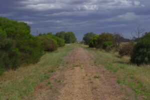
- A trail that blends into the landscape and occasionally challenges the rider with rough sections and stony creek crossings
- Complements MTB trails at the base of Mount Remarkable and surrounding forest areas
- Mt Remarkable, Alligator Gorge, Wirrabara Forest and the Southern Flinders Ranges provide an imposing backdrop
- Creek crossings are great fun!
Nearby Attractions
- Climb Mount Remarkable and walk through narrow Alligator Gorge
- Ride world-class MTB trails of Mt Remarkable and surrounding forests
- Ride the Pichi Richi Railway and visit the Flinders Ranges
- Enjoy the natural setting of Melrose, Booleroo Centre, Wirrabara and Laura caravan parks and campgrounds
Last updated: 28 August 2024
Overall description
The Southern Flinders Rail Trail consists of six sections that vary in terms of trail surface, scenery and topography:
- Idlib Road to Laura (3 km) – open farmland
- Laura to Stone Hut (10 km) – a good rural cycle path
- Stone Hut to Wirrabara (9 km) – follows the path of the Rocky River
- Wirrabara to Booleroo Centre (21 km) – through hills and along farmland
- Booleroo Centre to Melrose (17 km) – open farmland
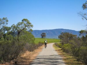
- Melrose to Wilmington (20 km) –follows the base of Mt Remarkable, then crosses open plains and small creeks
Please note that while the trail is referred to as the Southern Flinders Rail Trail, the section between Stone Hut and Wilmington is referred to as the Remarkable Rail Trail as it is within the Mount Remarkable District Council area.
Section Guides
Idlib Road to Laura (3 km)
This section runs parallel to the Horrocks Highway. The trail has not been constructed through Laura so directions have been provided to take you through the main shopping area and then onto the recommencement of the trail.
- Coarse gravel, suitable only for walkers and mountain bikes
- The trail starts at the junction of Idlib Road and Horrocks Highway, approximately 3km south of Laura.
- The trail terminates just south of Laura so, at the end of the trail, turn left, then right onto a rubble road, West Terrace. After a short distance, West Terrace becomes a sealed road. Take the third turn on the right, into Whyte Street and then turn left into the town’s main street, Herbert Street.
- Continue along Herbert Street until the dual lane ends and take the path through the North Laura Parklands (toilets, playground and BBQ) on the left. At the end of the path, continue on Mill Street and take the third turn on the left, Alexander Street, then the first turn on the right, West Terrace.
- Continue along West Terrace. The road will become a gravel road (stock Route Road) and once across Pine Creek, turn right and follow the creek until the road turns left. The Rail Trail recommences 50m along the track.
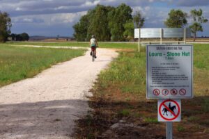
Laura and Stone Hut (10 km)
This section runs alongside Horrocks Highway and the Rocky River. The trail is a well compacted fine gravel surface which is suited to all types of bikes and cyclists of all abilities.
- Begins at the northern ‘Welcome to Laura’ sign
- The first few kilometres of this section also form part of the Mawson Trail
- The trail ends about 650m before Stone Hut so use the Horrocks Highway verge to ride to the Stone Hut Bakery.
- 70m past the Bakery, take the road on the left (Dee Road). The trail commences again, on the right, 40m from the intersection.
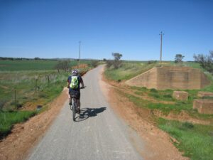
Stone Hut to Wirrabara (the Remarkable Rail Trail – 9 km)
An interesting section of the trail with several points of interest along the way. A good riding surface but best suited to mountain or hybrid bikes.
- 850m along the trail you will be required to cross Horrocks Highway. The crossing is not difficult but you need to keep your eyes open for fast moving vehicles.
- 150m along the trail where the Horrocks Highway vehicle bridge crosses the Rocky River, the trail bridge crosses the river nearby. You are able to see the old concrete embankments of the original rail bridge a few metres away. Take care on the steep approaches to the bridge and be aware that there is only room on the bridge for one way traffic.
- A further 3.5km along the trail and you will be required to cross Horrocks Highway again. Signage is not good but you will see the trail on the opposite side of the road.
- 300m further on, the trail leaves the edge of Horrocks Highway. Turn left onto Hollitts Road then right onto the trail.
- A kilometre further on the trail crosses Rocky River again but this time there is no bridge. The trail drops from the old rail line to the base of the old railway bridge embankments and you can then traverse the old concrete and stone base that is now the river bed. Its not a difficult crossing but the 2-metre flood level indicator should be a warning that it can be impassable.
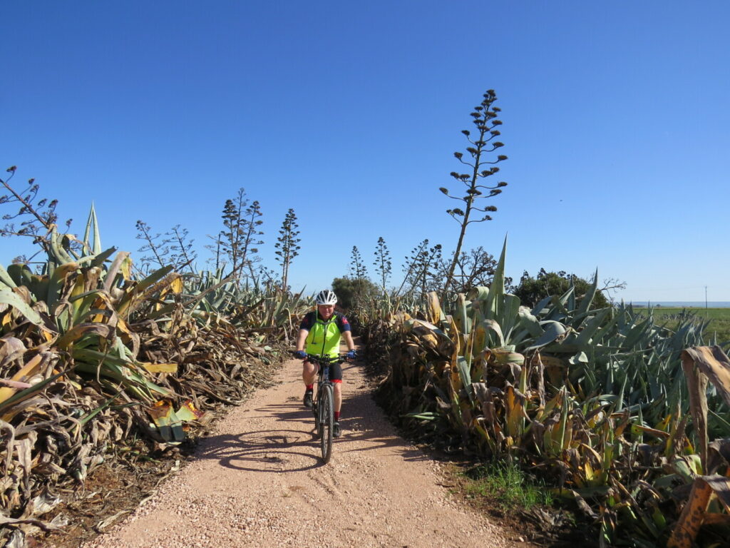
- Continue on and as you near Wirrabara you will notice the pine trees lining the trail. They are remnants of the pine forest planted in the area in 1877. The pine tree lined section of trail is about 300m long.
Please note that at the time of writing this trail description the trail signage had not been installed within Wirrabara. The following trail details have been provided so that you can navigate to the commencement of the trail to Booleroo Centre.
- When the trail meets Forest Road (a sealed road) turn left and a short distance down the road, the trail can be found on the right. You can take a short detour by following Forest Road to the right when you leave the trail. Follow Forest Road as it bends to the left and you will be able to view the silo art on the left. Return the way you came and turn right off of Forest Road as mentioned above.
- About 250m along the trail, use the bridge to cross Rocky River. Continue to the right and follow the trail for a further 350m and you will find Wongabirrie Park (toilets, shelter, BBQ and caravan park).
- Use the small foot bridge to cross toward Horrocks Highway where you can find the local bakery.
- Opposite Wongabirrie Park and on the right-hand side of Horrocks Highway, just past Kurrajong Street, is the well-hidden recommencement of the trail. There is a trail marker post on the edge of the road and the trail can be seen clearly from here.
Wirrabara to Booleroo Centre (the Remarkable Rail Trail – 21 km)
The first 25km of the trail have been a gentle climb (almost flat) with good shelter from the elements. The next 7km is a continuous but gentle climb which is not difficult unless you have a head wind. The trail surface is fine compacted gravel which is suited to mountain and hybrid bikes.
- The trail follows the Wirrabara-Appila Road until it veers to the north and heads toward the old rail siding of Yandiah.
- There are very few remnants of the railway however you may notice an old freight carriage on stilts which is used for farm storage. There is also a strange fence made up of a number of solid old steel railway gates
- After 6.5km the trail crosses Mahood Road, this is the highest point of the trail. The trail then slowly descends on its way to Yandiah. The feature of this section of trail is the stunning view out across the Appila Plains.
- The small and isolated town of Yandiah was established in 1874. All that remains today is an old railway siding (a few old sleepers). The construction of the railway in 1910 must have been a godsend for this small community. There is a plaque and Station Board on the edge of the road near the trail.
- It’s a pleasant drop along the edge of Pine Creek Road and then along Appila Road, leading into Booleroo Centre.
- The are a few curved narrow stock grids in this section. They seem to work well and are easy to cycle over as long as you reduce speed.
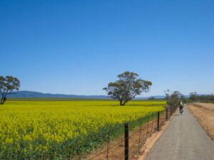
Booleroo Centre to Melrose (the Remarkable Rail Trail – 17 km)
This section was completed in September 2021 and is a good quality compacted fine gravel trail that follows the old railway alignment. The trail crosses four creeks as it moves through open farmland toward Mount Remarkable. The trial surface is compacted fine gravel however, due to the several creek crossing, the trail is best suited to mountain bikes.
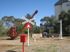
- Vehicles can be left in Booleroo Centre near the historic railway infrastructure display on the Corner of Campbell St and Arthur St. Public toilets and shops are located in Stephens St, further east along Arthur Street.
- The trail from Wirrabara ends adjacent to the Town Swimming Pool at Arthur Street. Slightly to the right is Campbell Street which takes you past the rail infrastructure display and then on past the silos and grain handling sheds. At the bend in Campbell Street the path appears on the left and then turns right and continues on to Colin Street where the trail leaves the town. Mt Remarkable can be seen in the distance.
- There are several interesting curved stock grates that you will need to ride over along the route – take care as they are narrow.
- 5km out from Booleroo Centre the trail crosses Perroomba Rd and on the left, a few timber sleepers mark the remains of Perroomba Station, which was the only station between Booleroo Centre and Melrose.
- As well as crossing a few minor roads, there are four creek crossings
- Bastion East creek – take care as the embankment has steep sides
- Bastion West creek – the trail crosses through the creek bed
- Collins Creek – the trail crosses through the creek bed past the concrete pylons of the original rail bridge
- Rotten Creek – this is the largest of the creeks and can have a steady flow after heavy rains. The trail crosses through the creek bed.
- Once past the Melrose silos the trail follows Girdham Rd to Horrocks Hwy where the trail crosses into the Melrose Showgrounds and then continues on the right to Wilmington. Turning left within the showgrounds will take you into the township of Melrose (2km). Paradise Square on the left in the centre of Melrose is a convenient location to rest.
Melrose to Wilmington (the Remarkable Rail Trail – 20 km)
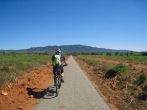
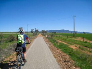
This section was completed in 2011 and is generally a good quality trail that follows the old railway alignment where possible. The trail surface is compacted fine gravel with some sections of coarse gravel and creek crossings, so it is best suited to mountain bikes. It features stunning views of Mt Remarkable to the west, and views of the Flinders Range to the east. The trail commences from Melrose however cyclists riding from Booleroo Centre can join the trail from the Showground entrance.
Note that the trail is best travelled between autumn and spring, and can be very hot in summer. Regardless of the time of year, take adequate water and food supplies and be aware that travel times can be slow due to creek crossings and wind. Wilmington cannot be relied on for food and water, but toilets are available.
- Begin from the corner of Joes Rd and Horrocks Highway, opposite the ‘Over the Edge’ cycle hire shop. Follow Horrocks Hwy 700 m north to Dorrington Rd; use the footpath if the road is busy
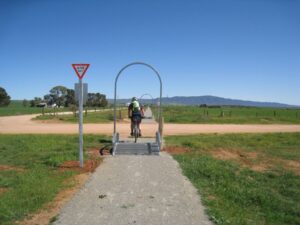
- At Dorrington Rd the trail enters private property through a gate on the corner. It is a privilege to use this private land; please leave as you found it. This section includes a ford across Willochra Creek and meanders through large eucalypts on its way to another gate at the entrance to Melrose Showground
- Follow the path around the Showground buildings and the old railway alignment to the gate at the northern end. The Showground is also a camping area; respect the privacy of those using the grounds
- The trail continues on the old rail alignment through open fields with Mt Remarkable behind you and the Southern Flinders Ranges to the left. The Flinders Ranges are in the distance to your right. The entrance to Willowie Forest Mountain Bike network is on the left
- Along this section you cross Goyder’s Line, a surveyed line that separates good cropping land from marginal cropping land (low rainfall). Surveyor George Goyder prepared the line (which can only be found on plans.) in 1865 by observing native plants while travelling 3200 km on horseback across SA. It has stood the test of time: you will notice the vegetation change as you ride north along the trail, particularly in open areas
- About 7 km from the Showground the trail crosses Horrocks Hwy and continues through open country with sweeping views of the plains to the northeast
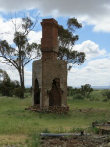
- After crossing Spring Creek, you will see an old chimney on the right, all that remains of the township and railway siding of Terka. The town was surveyed in 1924, but people showed no interest and the town failed to develop. The siding has also completely disappeared – a reminder of how difficult life in the Southern Flinders Ranges was in the early years of last century.
- A short distance from Wilmington is the last creek crossing. Stony Creek lives up to its name; dismount and walk across the stony creek bed. It’s an enjoyable walk that gives you time to take in the scenery
- At the end of the trail turn left into Gogler Rd, which veers to the right. Continue past the silos to Tuckwell St, a wide and substantial sealed road. Proceed up a slight rise past the primary school to the main road and the Wilmington Hotel. The hotel or shop/café may be open; if not, head down the street to the corner of Dignan St, where there is a small shopfront with self-serve machines for snacks and drinks. Public toilets are on the opposite side of the road, next to the fire station. Street signs are difficult to find; use features such as the silos, school, hotel and fire station
- Mobile phone coverage is limited
Start at Laura to Stone Hut (2011)
![Laura to Stone Hut [2011]](https://www.railtrails.org.au/wp-content/uploads/2023/10/S25-107-Laura-to-Stone-Hut-1-2011-11-300x169.jpg)
Laura to Stone Hut [2011]
![Rocky River bridge crossing near Stone Hut [2023]](https://www.railtrails.org.au/wp-content/uploads/2023/10/S25-155-Rocky-River-bridge-crossing-near-Stone-Hut-Oct-23-300x200.jpg)
Rocky River bridge crossing near Stone Hut [2023]
![Cruising between Stone Hut and Wirrabarra [2023]](https://www.railtrails.org.au/wp-content/uploads/2023/10/S25-155-open-trail-near-Stone-Hut-Oct-23-300x200.jpg)
Cruising between Stone Hut and Wirrabarra [2023]
![The trail crosses the Rocky River south of Wirrabara using the stone base of the old railway bridge [2023]](https://www.railtrails.org.au/wp-content/uploads/2023/10/S25-155-south-of-Wirrabara-Rocky-River-rail-bridge-embankment-Oct-23-300x200.jpg)
The trail crosses the Rocky River south of Wirrabara using the stone base of the old railway bridge [2023]
![Trail marker near Wirrabara [2023]](https://www.railtrails.org.au/wp-content/uploads/2023/10/S25-200-Trail-marker-Wirrabara-Oct-23-300x200.jpg)
Trail marker near Wirrabara [2023]
![Pine tree tunnel approaching Wirrabara 2023]](https://www.railtrails.org.au/wp-content/uploads/2023/10/S25-200-Wirrabara-pine-tree-tunnel-2-Oct-23-300x200.jpg)
Pine tree tunnel approaching Wirrabara 2023]
![Silo art at Wirrabara [2023]](https://www.railtrails.org.au/wp-content/uploads/2023/10/S25-200-Wirrabara-silo-art-Oct-23-300x200.jpg)
Silo art at Wirrabara [2023]
![Creek crossing on the climb from Wirrabara up to Yandiah [2023]](https://www.railtrails.org.au/wp-content/uploads/2023/10/S25-205-40.03-Creek-crossing-near-Wirrabara-Oct-23-300x200.jpg)
Creek crossing on the climb from Wirrabara up to Yandiah [2023]
![View of the Appila Plains from the top of the range near Yandiah siding [2023]](https://www.railtrails.org.au/wp-content/uploads/2023/10/S25-205-40.08-Appila-Plains-from-Yandiah-Oct-23-300x200.jpg)
View of the Appila Plains from the top of the range near Yandiah siding [2023]
Railway Infrastructure display - Booleroo Centre (2021)
Collins Creek Crossing next the remains of the rail bridge (2021)
Canola crop near Booleroo Centre (2021)
Bastian Creek vegetation near Booleroo Centre (2021)
Decorative stock grate at Bastian Road (2021)
The approach to Rotten Creek with Mt Remarkable in the background (2021)
West of the former Perroomba Station site (2021)
![Melrose is starting to embrace cycling tourism [2021]](https://www.railtrails.org.au/wp-content/uploads/2023/10/S25-307-Melrose-Over-the-Edge-bike-shop-2021-08-ECONOMY-300x225.jpg)
Melrose is starting to embrace cycling tourism [2021]
![Large gum trees near Melrose Showgrounds [2020]](https://www.railtrails.org.au/wp-content/uploads/2023/10/S25-307-Melrose-large-gums-near-Melrose-Showgrounds-2020-09-300x225.jpg)
Large gum trees near Melrose Showgrounds [2020]
![Willochra Creek crossing [2020]](https://www.railtrails.org.au/wp-content/uploads/2023/10/S25-307-Willochra-Creek-ford-2020-09-300x225.jpg)
Willochra Creek crossing [2020]
![The Willowie Forest north or Melrose [2020]](https://www.railtrails.org.au/wp-content/uploads/2023/10/S25-307-Willowie-Forest-1-2020-09-300x225.jpg)
The Willowie Forest north or Melrose [2020]
![Willowie Forest area bridge [2020]](https://www.railtrails.org.au/wp-content/uploads/2023/10/S25-307-Willowie-Forest-area-bridge-2020-09-300x225.jpg)
Willowie Forest area bridge [2020]
remains of a chimney at the Terka Station location 2020
![Terka, heading toward Mt Remarkable [2020]](https://www.railtrails.org.au/wp-content/uploads/2023/10/S25-355-Terka-heading-toward-Mt-Remarkable-2020-09-300x225.jpg)
Terka, heading toward Mt Remarkable [2020]
![Crossing Stony Creek near Wilmington [2020]](https://www.railtrails.org.au/wp-content/uploads/2023/10/S25-406-crossing-Stony-Creek-near-Wilmington-2020-09-300x225.jpg)
Crossing Stony Creek near Wilmington [2020]
Laura to Gladstone (2011)
Sign on Laura to Gladstone section (2011)
 Leaders in Rail Trail Bicycle and E-Bike Hire in the Yarra Valley and Yarra Ranges. Customise your own riding adventure and help us support local businesses along the way. Family run and owned with extensive local knowledge, bike hire has never been so easy.
 Need a drop off or pick up on the rail trail? We can carry up to 11 passengers and up to 14 bikes on a Shingleback trailer. Call Don for more info and pricing.
Over the Edge Sports https://rentbikesmelrose.otesports.com/rentals or call +61 (0) 88 666 2222
Do you know of a bike hire or transportation service on this rail trail that should appear here? If so, let us know at admin@railtrails.org.au.
 Provides accommodation for up to 26 people in bunk style and ensuite style rooms with a communal meeting area with kitchen facilities and a separate barn style lounge/games area. Located within walking distance to all the essential attractions within the township of Melrose. Bike storage, lock up and bike wash on site.
Information and Links
See Services tab above for links to services and businesses along this trail
For more information:
The trail from Stone Hut to Wilmington is managed by Mount Remarkable District Council and the section from Laura to Stone Hut is managed by Northern Areas Council
To report problems contact
Mt Remarkable District Council 8666 2014
ce**@mt*.au
Northern Areas Council 8664 1085
ad***@na*******.au
“>
ad***@na*******.au
Contact Rail Trails Australia
To contact us about this rail trail, email sa@railtrails.org.au
Background Information
Traditional owners
We acknowledge the Nukunu people, the traditional custodians of the land and waterways on which the trail is built.
Rail line history
A narrow gauge railway once connected the towns of Gladstone, Laura, Stone Hut, Wirrabara, Yandiah, Booleroo Centre, Perroomba, Melrose, Terka and Wilmington. It started in Gladstone in June 1884 to serve the rapidly developing wheat growing region and was opened to Wilmington by 1915. The last train left Wilmington’s wheat silo in July 1988.
Gladstone was once a busy and important station with a mixture of narrow and broad gauge lines. It had main lines from Adelaide, Peterborough and Port Pirie, and branch lines to Wilmington and a munitions depot. It had grain silos, sheep and cattle yards, goods sheds, loco sheds, a turntable, and an impressive railway station. Little remains today.
Development and future of the rail trail
It is hoped that the trail can be extended 7km south to Gladstone. This would mean that the Gladstone to Wilmington branch line, which was constructed between 1883 and 1915, would be converted to a rail trail for its entire 87-kilometre length.
A remarkable effort produces a remarkable Rail Trail
Posted: 24/10/23
The District Council of Mt Remarkable has completed the final stage of the Southern Flinders ...
More...Construction Commences on Southern Flinders Rail Trail extension
Posted: 17/02/22
Clearing of the trail has commenced at Booleroo Centre and design work for bridges, culverts ...
More...Southern Flinders Rail Trail extension to Booleroo Centre officially opened
Posted: 22/09/21
Turning the first sod to start construction of the ...
More...17 km extension to the Southern Flinders Rail Trail in South Australia commences
Posted: 31/05/21
The existing 22km Southern Flinders Rail Trail rail trail from Wilmington to Melrose is being ...
More...Southern Flinders Ranges Rail Trail to triple in length
Posted: 16/04/21
The Southern Flinders Ranges Rail Trail in South Australia is to be extended 42km from ...
More...Grant funding for Southern Flinders Ranges Rail Trail (SA)
Posted: 17/05/20
The District Council of Mount Remarkable will match the South Australian Governments Opens Space and ...
More...Nearby Trails
Shamus Liptrot Rail Trail
100km north of Adelaide
11 km


Copper Rail Trail
100km north of Adelaide
26 km

Riesling and Rattler Rail Trail
130km north of Adelaide
53 km


Nearby Trails
Shamus Liptrot Rail Trail
100km north of Adelaide
11 km
Copper Rail Trail
100km north of Adelaide
26 km
Riesling and Rattler Rail Trail
130km north of Adelaide
53 km

15 reviews of “Southern Flinders Rail Trail”
When we last ride the Melrose to Booleroo section, we found the trail extremely bumpy from the corrugated surface. Also, two gates at one farm near Booleroo were locked to a point it was difficult to get through. The farmer let's his sheep use the trail therefore be prepared for a bumpy ride. Apart from that, it's a great trail with lovely views of the Mount.
The section between Stone Hut and Wirrabara is now open except for a small section, which is easy to go around. To avoid this section cross the road from the Stone Hut bakery and follow rail trail until section ends. Then cross road again and follow on other side. At P. Hollitts Rd cross the Highway again and take the Wirrabara Forest cycling trail which ends near the beautiful painted silos. Trail is reasonably well marked and well kept. Round trip Laura-Wirrabara -Laura is about 35 kms.Try the bakery at Wirrabara, its fantastic. Then on return try Stone Hut Bakery too.
This trail is all rideable now from Laura to Wilmington – approx 76kms total. The Melrose to Booleroo Centre section has been cleared & is now fine. No doubt the regrowth after a wet winter may need at least annual maintenance. The newest completed section from Wirrabara to Booleroo Centre has a slight climb and is probably the nicest section in my opinion, although the surface may be a bit soft. Interesting that the Mt Remarkable Council has a) renamed it as "the Remarkable trail" on its distance signposts & b) starts it at Stone Hut! There are many dirt rds surrounding the rail trail allowing for nice loops of every section.
The first section that was completed, & that with the best surface, from Laura to Stone Hut has been left off (different council!).
Laura has IGA, pub, caravan pk & lots of shops
Stone Hut has a famous bakery & accomodation.
Wirrabara has a great bakery, pub, caravan park & general store with limited hours & stock.
Booleroo Centre has a great supermarket, no pub, community camping at showgrds.
Melrose has 2 pubs, brewery, OverTheEdge bikeshop & cafe, great museum, caravan park plus camping 2kms N at showgrounds.
Wilmington – limited food options, pub does meals, there is a vending machine on the S side of the street open 24hrs, 2 caravan parks on the outskirts of town, op shop, toy & puppet museums.
I rode this trail last week in two sections: Melrose to Wilmington and return, and then Melrose to Booleroo return. The section to Wilmington is in good condition and easy riding with just a couple of minor washouts across the trail. There is a cafe in Wilmington that was open on a week day for refreshments.
The section from Melrose to Booleroo was, on the first day’s inspection, impassable. The trail was choked with a thick woody and thorny weed from the start just past the silos. However, the following day, a council mini excavator had cleared the trail for about seven kilometres. However, about six kilometres from Booleroo, the trail again became almost impassable with the same weed. Pushing through the weed resulted in scratched legs so a check on Google maps showed a gravel road, Perroomba Road, running largely parallel with the trail. This was far more pleasant to return ride back to where it was possible to get onto the trail. It also avoided two cockies gates (strand wire temporary gates) on that section of the trail.
I went to the Council Offices the next day and found out that the Council’s weed spraying equipment had broken down and when they went to slash the trail verges, the slasher started a grass fire. So, it had been let go over the past growing season. But, I was assured that maintenance was now proceeding for the entire section through to Booleroo. It would be worth checking at the Council Office in Melrose beforehand if you plan to ride this section presently.
Melrose to Booleroo review….very disappointing. Totally overgrown with weeds most likely from the wet winter. At times not ridable due to height of weeds that cut our legs and one section blocked by farmers allowing sheep to graze…maybe to help with weeds. Our group of 4 diverted onto side roads into Booleroo Centre as the trail was so bad. Also there were cracks in the track that your wheels sunk into. Signage was poor from Melrose, no sign at Showgrounds gate or the road opposite towards Booleroo. (Silo trail sign??, whatever that is), In fact you wouldn't know a rail trail to Booleroo existed.
It seems this section of trail may have been poorly built,but hopefully it will be maintained in future or it will never be used which is very sad.
The trail section from Wilmington to Melrose is great, just needs better signage at Cordon Rd to divert you into the back of the showgrounds towards Melrose. Read the notes on this page carefully before riding.
Hi Michelle,
Thanks for your feedback on the Melrose to Booleroo Centre section of the trial. I visited a trail in the lower section of the Southern Flinders recently and encountered similar problems with overgrown vegetation. I think this is a combination of a long, wet winter and a lack of Council resources to clear this heavy growth. I know that the Council is flat out constructing the Booleroo to Stone Hut section (it’s well behind due to the wet winter) so that may have taken resources away from maintaining other sections of the trail. The Council is committed to improving the condition of the trail so that it is consistent with the Wilmington to Melrose section but I don’t expect that we will see any great change until mid-2023. I believe that the signage will be addressed during the completion of the Booleroo to Stone Hut section. Once the trail is complete to Stone Hut, I will ride the total length (88km) and provide comments to the Council in relation to improvements that are required. I have referred your comments onto the Council.
Regards Mark
Thanks Mark appreciate your input ( sorry re late reply) but I believe this has been cleared.
Michelle
A really great ride this October with crops at record heights from Wilmington to Melrose to Bolero Centre and then on to Laura.
I will certainly ride these trails again next year
We rode from Laura to Wirrabara and return yesterday, June 2022.
The first section to Stone Hut has been available for more than 12 years and has a very good hard packed surface, and is approx 8km in length. The local council is now in the process of building the next 6km towards Wirrabara. We rode on the road next to the old railway corridor, and we're able to observe the progress. We then joined back onto the finished trail into Wirrabara another 3kms. I think this is the best part of the trail as it goes through some nice cuttings and a tunnel of pine trees near Wirrabara. The painted silos at Wirrabara are fantastic and well worth a look.
I have been informed that the last section will be completed by end of June 2022,but wet weather is delaying work at the moment.
The road has very little traffic, is smooth and has a wide shoulder.
It was disappointing to see that the avenue of planted trees near Laura has been trimmed down to about 3 metres high, because they are in the vicinity of a power line. A bit over the top by the tree trimming contractors.
Our return trip was about 38kms, a nice easy ride. A good bakery at Wirrabara, and also at Stone Hut. No bakery at Laura, but a really good new coffee shop. We stayed in a beautiful cabin at Laura Caravan Park. Highly recommended.
Rode Melrose to Booleroo. Very exposed trail through expanses of cropping properties with little tree coverage. Tree plantings are taking place at various sites, which is pleasing.Good surface,but a hot ride in summer and hard work on a windy day like we had. Booleroo has an IGA, but Melrose does not have a supermarket. However, Booleroo has no hotel and Melrose has two and two coffee shops plus a bike shop. Rode Melrose to Wilmington trail where the surface has improved immensely since 2011. Very scenic 22k's one way ride with Mt. Remarkable on one side and Flinders Ranges in the distance on the other side. Earlier tree plantings make for cover on the trail. Many new little bridges means only 3 off trail creek crossings. No coffee shop in Wilmington, nor supermarket. Pub still open.
We visited this trail in June 2022. It was cold and a little bit wet, but the trail is in good condition.
We did the Melrose to Booleroo section and return on day 1. The surface is a hard packed crushed blue metal, which follows the old rail corridor for most of the 20kms. There are three missing low level bridges, but the detours are quite satisfactory, and not at all steep.
On our second day we rode to Wilmington and return for a total of 45kms.
This section of trail has a lot of tree cover for the first 10km, and a very smooth surface. The next 10km offers wonderful views of the distant Flinders Ranges on one side, and Mt Remarkable on the other side.
Most of the small bridges have been replaced with a sturdy steel decking and rails. Three larger bridges are missing and a side detour is provided. Not steep or wet. However the one closest to Wilmington is very rocky, and we had to walk through it.
We stayed at the Melrose Holiday Units in Whitby Street. They have 6, 2 bedroom units at only $95 per night for a couple. The units are spacious, with full kitchen and modern bathroom. Comfortable bed and quiet split system Air Conditioning. We stayed for 3 nights, and would highly recommend it to anyone wishing to stay in Melrose.
A great little coffee shop and bike shop called Over The Edge is in the middle of Melrose. Very good coffe and cake, and the bike shop does bike hire at a reasonsble rate.
We moved to the Laura Caravan Park for the third section of this trail. Laura to Stone Hut is the oldest section of this trail, and is a real pleasure to ride.
Rode the section from Gladstone to Laura, good dirt road for 7.5km in the dry from Gladstone to the end of the 2.5km of actual gravel rail trail. Give it a miss if wet though. Passes through mostly open farmland and off the bitumen, when dry the dirt bit would be ok on a gravel or mountain bike.
Cycled the Melrose Showgrounds to Wilmington return. Sunny warm early Autumn day. Trail departs North end of Showgrounds through iron gate. Kilometre markers along the flat trail in both direction. Surface to first road crossing excellent fine gravel, then done courser gravel and fine gravel closet to Wilmington. Mid week March Pub open, Pizza/ takeaway open, and there is a 24 hour vending machine place North end near petrol station. An enjoyable section with views of Mount Remarkable NP and the plains.
Rode Melrose to Wilmington on 3 December 2020. A very scenic rail trail, definitely MTB-suited as it becomes quite gravelly once out of Melrose. Nice creek crossings, saw kangaroos and found a council worker clearing a fallen tree. I am looking forward to the new section opening.
We were on the trail on a very warm day – there is not a lot of tree coverage in some sections, and you need to take plenty of water.
Just rode Melrose to Wilmington track and found it to be not too bad. Local bike shop owner advised it was pretty rough and it was, with rocks all along the graded track. MTB’s for sure. Great fun though and made a nice change from the single track action around Mt Remarkable, with great views of the mountain. It’s great to see the rail corridor getting used, especially for biking!