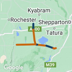
- The trail connects Murchison on the Goulburn River with the Waranga Basin along Channel Inlet Rd and includes the refurbished historically significant bridge over the Stuart Murray Canal
- This almost level rail trail traverses former gold mining and cropping country, and the unique ecosystem of Doctors Swamp wetland, which has a Parks Victoria picnic ground on its western boundary.
- The extension to Rushworth is planned to be completed by April 2025.
- The Stanhope Girgarre Rail Trail is on the same corridor and will hopefully link up in the future.
Nearby Attractions
- A small park in Murchison is dedicated to the meteorite’s impact, which was heard, observed and smelt one quiet Sunday morning. The meteorite weighed more than 100 kg and the oldest material found on Earth, silicon carbide particles estimated to be 7 billion years old.
- Waranga Basin – the fourth-largest inland waterway in Victoria and an important off-river storage supplying water to many irrigation areas as well as nearby towns – was the first major dam built in Australia. The first stage of construction began in 1905 using hand tools and horse-drawn scoops. At the time it was the largest project of its kind in the world.
Last updated: 17 April 2024
Note: This trail is partially open – it is due for completion to Rushworth in April 2025.
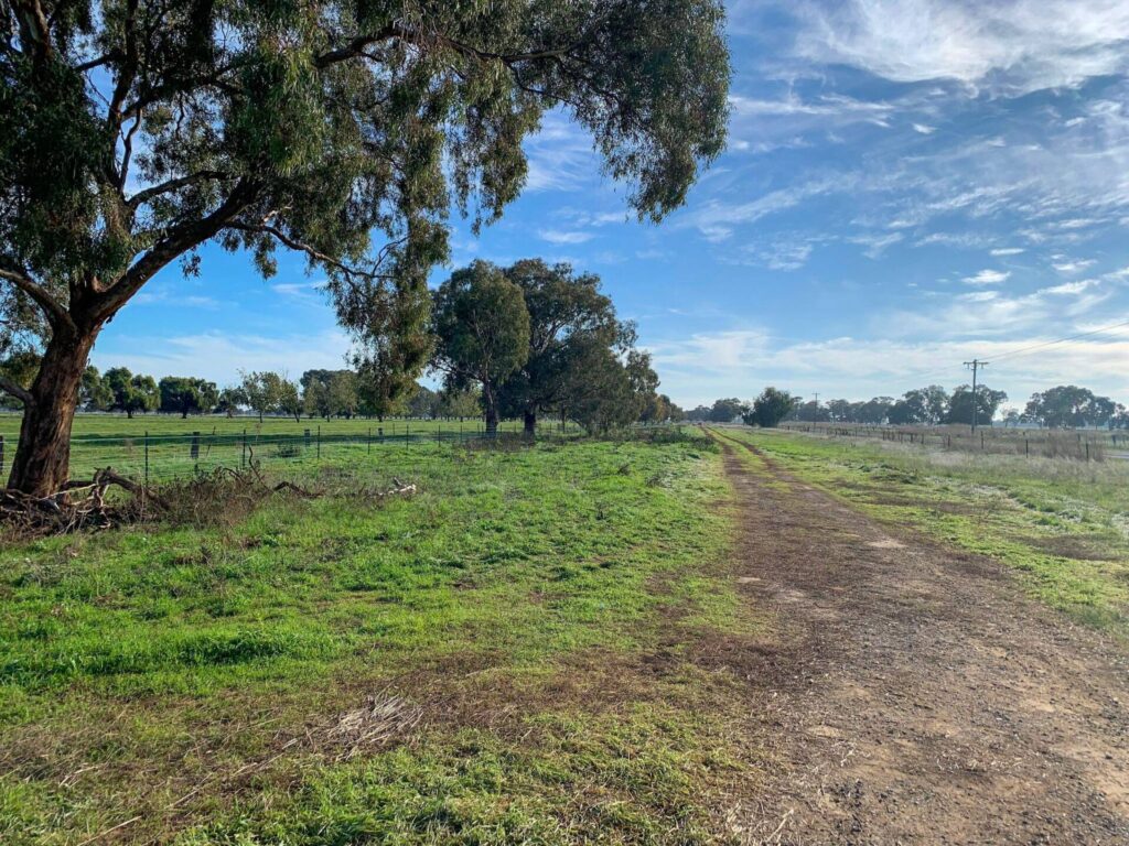
Murchison to Channel Inlet Road (8 km)
- Starts near the end of Impey St in Murchison and ends at Channel Inlet Rd
Murchison is a small regional town with a bakery-cafe and picnic and toilet facilities beside the Goulburn River
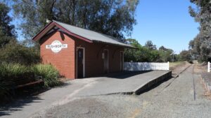
Rushworth (2 km)
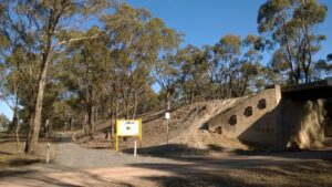
- The community of Rushworth bought the land and infrastructure around the station to retain it for posterity. There are plans for this short section of trail to be linked with the end of the Murchison section
Rushworth is a small regional town with a bakery-cafe, ice cream shop and other limited facilities
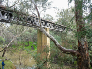
The impressive bridge over the Goulburn River at Murchison. This would be part of a future extension to Murchison East.
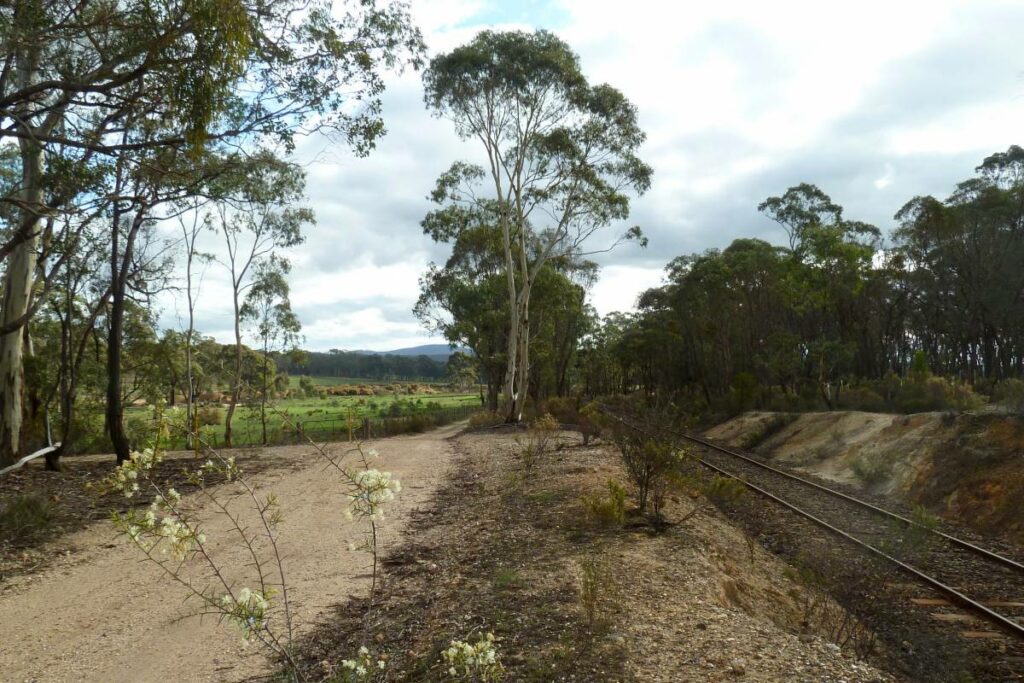
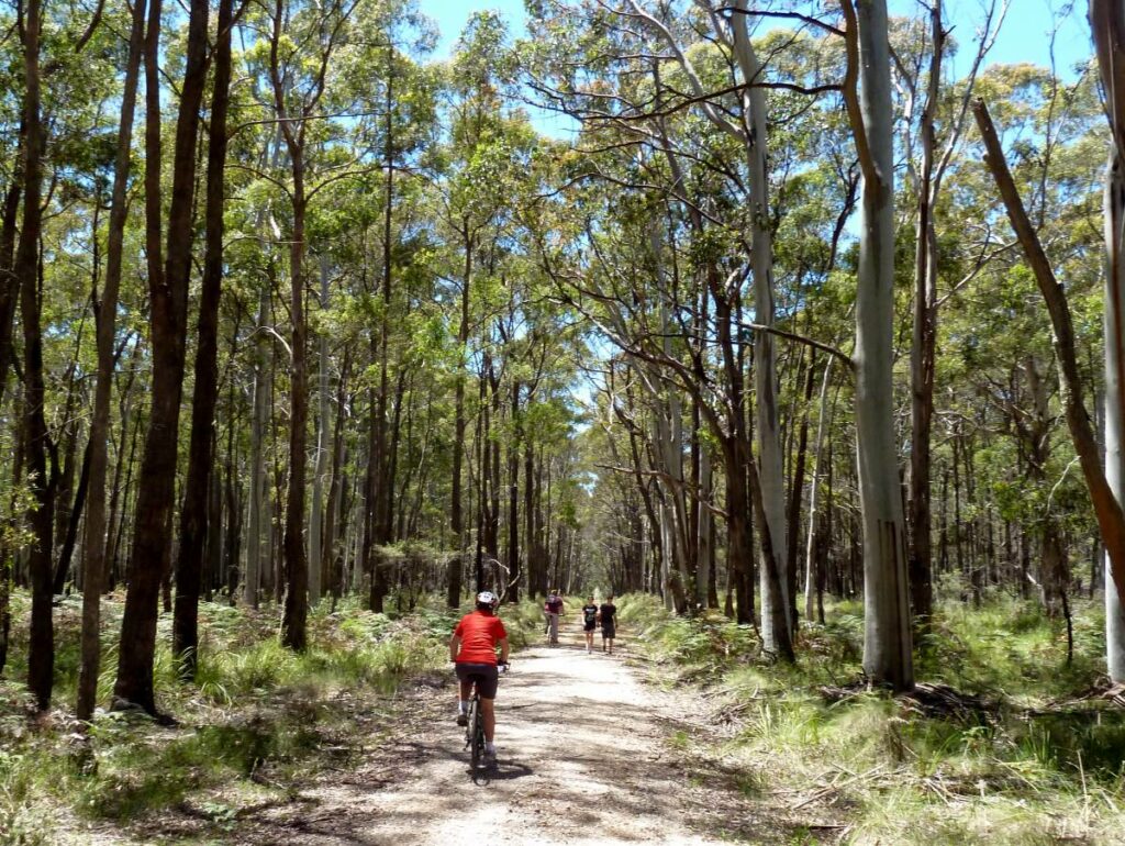
![The rail trail near Murchison [2015]](https://www.railtrails.org.au/wp-content/uploads/2022/07/V48-060-Murchison-2015-12-249-300x169.jpg)
The rail trail near Murchison [2015]

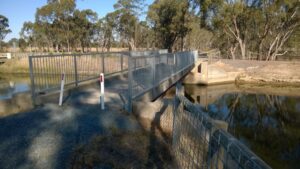
The restored timber bridge across the Stuart Murray Channel. (2012)
Another bridge on the Murchison section (2015)
The current end of the main rail trail at Channel Inlet Rd (2015)
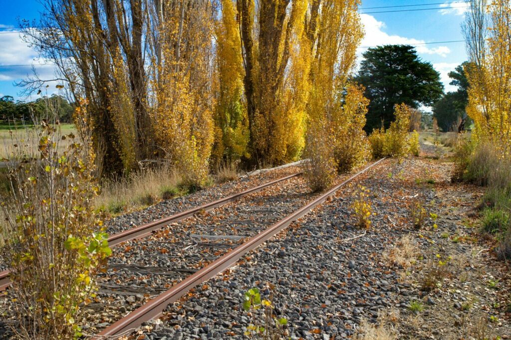
![The rail corridor at Waranga Basin [2012]](https://www.railtrails.org.au/wp-content/uploads/2022/07/V48-107-Waranga-Basin-2012-0329-300x169.jpg)
The rail corridor at Waranga Basin [2012]

The Rushworth station precinct (2012)
The Rushworth 'Comfort Station' (2012)
![Part of Historic Rushworth [2012]](https://www.railtrails.org.au/wp-content/uploads/2022/07/V48-158-Rushworth-2012-0316-300x169.jpg)
Part of Historic Rushworth [2012]
![Silo art at Colbinabbin which may be a future extension of the rail trail [Garry Long 2021]](https://www.railtrails.org.au/wp-content/uploads/2022/07/V48-405-Colbinabbin-silo-art-2021-10-27_143830-300x225.jpg)
Silo art at Colbinabbin which may be a future extension of the rail trail [Garry Long 2021]
Do you know of a bike hire or transportation service on this rail trail that should appear here? If so, let us know at admin@railtrails.org.au.
Information and Links
The trail is managed by Greater Shepparton City Council and Shire of Campaspe. Refer to their websites below to report issues.
Contact Rail Trails Australia
To contact us about this rail trail, email vic@railtrails.org.au
Background Information
Traditional owners
We acknowledge the Ngurrai-illam-Wurrung and Taungurung people, the traditional custodians of the land and waterways on which the rail trail is built.
Development and future of the rail trail
Greater Shepparton City Council opened the Murchison to Channel Inlet Rd section in 2015.
The Shire of Campaspe has obtained a lease from Victrack to develop the rest of the corridor from Waranga Basin to Rushworth. Funding for this section was obtained in February 2022 and completion is planned for April 2025
Extending the trail to the Melbourne-Shepparton rail line at Murchison East would allow better access from public transport, but making the large bridge across the Goulburn River safe will be a significant undertaking.
The Girgarre community is planning to extend its section to Stanhope and in future back to Rushworth.
Campaspe Shire is seeking funding to build this as part of the Heathcote to Murchison Trail (outline brochure here) to link to the O’Keefe Rail Trail at Heathcote.
Rail line history
A line from Murchison East on the Shepparton line was built to the gold mining town of Rushworth in 1890 and extended to Colbinabbin in 1914. Rushworth became a junction when a line was built to Girgarre in 1917. A diversion of the line was necessary when the Waranga Basin was built. All lines were closed by 1987.
Rushworth Rail Trail now heritage listed
Posted: 06/03/24
After detailed historical and site investigations, Heritage Victoria have placed the former Rushworth Railway Station ...
More...Rushworth Rail Trail update
Posted: 23/11/23
Campaspe Shire Council have recently provided an update on the Rushworth Rail Trail project which ...
More...Waranga Basin Fish Habitat Installation Project linked to Victorian Rail Trail
Posted: 06/10/23
A very interesting and environmentally important project has commenced at the Waranga Basin. The Campaspe ...
More...Rushworth Murchison Rail Trail Project Update
Posted: 02/07/23
Campaspe Shire Council, who are the project leads on the Rushworth Murchison Rail Trail in ...
More...Paul Baker returns to Northern Victoria and rides three trails in one day
Posted: 18/06/23
We recently featured Paul Baker riding the O’Keefe Rail Trail which was his 29th ...
More...Central Victorian Rail Trails feature in Paul Baker’s latest rides
Posted: 06/06/23
Paul Baker, an enthusiastic rider who is aiming to ride every rail trail in Victoria ...
More...Rushworth to Murchison Rail Trail Project
Posted: 22/01/23
Rushworth to Murchison Rail Trail Project (Waranga Section) Update The exciting 11km extension to the ...
More...Funding at last to complete the Murchison Rushworth Rail Trail
Posted: 13/03/22
Finally the funding ducks have aligned to enable completion of the Murchsion Rushworth Rail Trail ...
More...Construction Starts on Murchison Rail Trail (Northern Victoria)
Posted: 25/05/14
Soon more than just kangaroos will be able to ...
More...Murchison to Rushworth Rail Trail (Vic) Development Starts
Posted: 03/11/13
Greater Shepparton City Council has received funding of $150,000 towards the Murchison stage of the Box ...
More...Nearby Trails
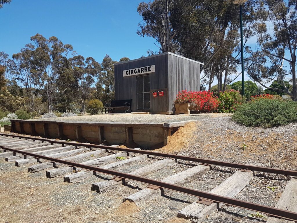
Girgarre Stanhope Rail Trail
200km north of Melbourne
5.5 km


O’Keefe Rail Trail
East of Bendigo, 150km from Melbourne
50 km
Lockington to Kotta
198km north of Melbourne

Dookie Rail Trail
North East Victoria, 220km from Melbourne
8 km


Great Victorian Rail Trail
90 km north of Melbourne
134 km
Castlemaine to Maldon Railside Trail
120km north west of Melbourne
18 km
Castlemaine to Maryborough Rail Trail
Central Victoria, 124 km from Melbourne
Woodend to Daylesford (incl Domino) Rail Trail
85km north west of Melbourne
5 km
Nearby Trails
Girgarre Stanhope Rail Trail
200km north of Melbourne
5.5 km
O’Keefe Rail Trail
East of Bendigo, 150km from Melbourne
50 km
Lockington to Kotta
198km north of Melbourne
Dookie Rail Trail
North East Victoria, 220km from Melbourne
8 km
Great Victorian Rail Trail
90 km north of Melbourne
134 km
Castlemaine to Maldon Railside Trail
120km north west of Melbourne
18 km
Castlemaine to Maryborough Rail Trail
Central Victoria, 124 km from Melbourne
Woodend to Daylesford (incl Domino) Rail Trail
85km north west of Melbourne
5 km
9 reviews of “Murchison – Rushworth Rail Trail”
It's bizarre that they call this the Murchison-Rushworth trail. There is no connecting trail. It's been proposed for construction for 2 years. The Rushworth end is closed and the Murchison end 7km has been covered in crushed rock, very uncomfortable and unenjoyable to ride. Only suitable for mountain bikes at best. The middle 7-9km of trail between the two towns doesn't exist.
Appreciate you providing a review of the condition of the partially open rail trail Scott. The name reflects what the rail trail will eventually be and almost all the rail trails we have now have opened in stages. As you have mentioned the rail trail is currently under development and Campaspe Shire have announced the 11km construction will commence from the Rushworth end shortly. We will request an updated completion date and update the description. Regarding the surface of the open section please politely let Greater Shepparton City Council know (contact details below under Further Info) and we will also inquire further about this.
Would be great if the two parts of this trial joined up. Despite being open since 2015, Rushworth and Murchison are both still missing out on cycle tourists who would love to be able to ride between the towns on an off road rail trail. The trail has good lake views and good interpretive signage. Also interesting history of the beginning of irrigation. Surface on sections completed is blue metal and very rideable. Other sections are rough, unformed but rideable.
Rode from Murchison to the end of the trail, then on the highway to Rushworth for coffee and the best banana bread I have ever had.
The trail at the Murchison end has a blue metal surface which is quite loose in sections.
It is disappointing to see that the trail has not been completed all the way to Rushworth. A sign at the end indicated that 3 million dollars had been funded and it is supposed to be completed by April 2024. Most of the corridor looks in good shape, including some intact concrete bridges. So it shouldn’t be too Hard to finish the job.
The Rushworth end is really great, albeit very short. It was especially good to see some railway infrastructure still in place, hopefully to be restored and treasured for future generations.
I rode this on the Easter Monday, 2023. From Murchinson East Railway Station you can ride the ~2km Murch township (and the start of this trail) using the segregated footpath/cycle path. There are some food options near the big pub. The ~8k trail is well maintained, even after the flooding with lots of information boards.
The trail surface is course blue gravel that you can maintain a reasonable speed on and feel comfortable on unless you are on fairly thin tyres. The Wallabies, Roos and birds kept me company along the route.
I rode on to Rushworth via the highway in places and found Easter traffic annoyingly close and constant. The road is not really ideal due to lack of shoulders and passing caravans.
The second part is paved and avoids the remaining rail infrastructure which is almost complete however do NOT ride through the railway area as mutant bindis (thorns) that appear to have been grown at Maralinga. I had about ten in the front tyre and about 12 in the rear. Not all penetrated but the IGA at Rushworth had a bike tube repair kit after I ran out of spare tubes and patches.
The big question is why? Why are there two parts of the trail separated by a gap of pristine bush with water views? Rushworth is calling out for a steady stream of riders to lift their retail area and motel and this would be a decent distance and a high calibre trail with easy rail access.
This is an excellent trail looking for some distance however, do try it if you are in the area.
The blue metal track is pretty loose in places but not hard to ride any moderately experienced cyclist on a bike with 30 mm or wider tyres. Quite flat. The track appears to have regular maintenance and is family friendly.
Nice crushed blue metal track, flat from Murchison heading towards Rushworth. Easily tackled with a hybrid bike.
I did the short 2km ride from Girgarre. Had an encounter with 2 large Irish Wolfhounds right at the end of the trail. They were friendly enough at first, but having that chase drive, they were a handfull, able to keep up with me going flat out with their noses right at my thighs… They chased me coming and going unfortunately.
We rode this new Rail Trail on 29/3/15; it was easy to ride with hybrid bikes. We rode to the current end (Channel Inlet Road) and back, had lunch at the Murchison Bakery – and a stroll around the nearby landscaped, river bank area. We are looking forward to being able to ride all the way to Rushworth on this trail and think it will be a fantastic experience to ride into what is a well preserved old country railway precinct. (Congratulations to the Rushworth community for preserving this area for posterity.)
I rode this trail on Saturday 13th December 2014 (along with the Dookie trail). First off – the section between Murchison and Waranga Bushland reserve is open – and much more interesting than the small section in Rushworth. The trail from Murchison is flat and good bridges across the canals. Once you come to the end of the trail at Waranga Bushland – the rail reserve continues on – and it is evident that others have continue to ride along the reserve, though Victrak have signs everywhere stating it is prohibited to ride on the rail easement. I saw no one the entire ride – so if you want to get away from the crowds, then this ride is for you.